1920s Maps of McGee Ranch, Arizona
Explore 2 historic maps of McGee Ranch from the 1920s. These maps offer a rare glimpse into what life looked like during the 1920s — showing old roads, neighborhoods, homes, and landmarks that have changed or disappeared over time.
Whether you're researching your family's past, planning a metal detecting trip, or studying how McGee Ranch's landscape evolved across the 1920s, these high-resolution maps are a powerful tool for exploring the history of this region.
- Focus on a specific era: All maps on this page are from the 1920s, giving you a focused view of this time period.
- See what’s changed: Compare century-old streets, trails, and buildings to today's modern landscape using overlays and satellite layers.
- Research with precision: Use these maps for genealogy, historical research, land use analysis, or educational projects.
- View, download, or print: Maps are fully viewable online in high resolution, and can be downloaded or printed for your own records.
Start exploring McGee Ranch's history through authentic maps from the 1920s. This is your window into the past.
McGee Ranch, AZ maps
(2)- 1920 Map of Arivaca
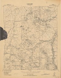 1920 Arivaca1920 Print · USGSSouthern Arizona ranching and mining country comes into focus in this post-World War I survey of the Santa Cruz Valley. Trace family roots and early industry near the Tumacacori Mission, Oceanic Mine, and the village of Arivaca.
 - 1925 Map of Samaniego Peak
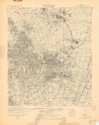 1925 Samaniego Peak1925 Print · USGSIn the mid-twenties, this Pima County landscape was a mix of isolated desert homesteads and active mining operations. Genealogists and historians can trace family-named locations like Perones Ranch and Mendoza Ranch or explore the rail-and-ore history of the Southern Pacific Railroad.
End of results
Showing maps 1-2 of 2
Top cities near McGee Ranch
Frequently asked questions
- What are the different types of historical maps available for McGee Ranch?
- What is the oldest map of McGee Ranch?
- Where can I purchase historical maps of McGee Ranch for my home or office?
- Where can I download high-res historical maps of McGee Ranch?
- Are there historical topographic maps available for McGee Ranch?
- Is there historical aerial imagery available for McGee Ranch?
- Where are historical maps of McGee Ranch sourced from?