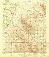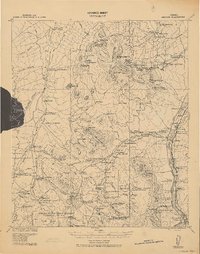
1920 Map of Arivaca
USGS Topo · Published 1920About this map
The Santa Cruz River corridor serves as the primary artery through this southern Arizona landscape, connecting established settlements like Tubac and Amado. The map details a transition from river-bottom agriculture and irrigation near the Irrigation Pumps Station to the hard-rock mining and ranching interests in the surrounding ranges. Isolated wells and pumps, such as E. Kings R. Well & Pump and the San Jose Ranch Well & Pump, underscore the vital importance of water rights in the arid terrain between the Sierrita Mountains and the San Luis Mts.
Find a feature on this map
102 named features on this map. Tap any name to fly to it.
Don’t see what you’re looking for? This feature index may not catch every label — zoom into the map to look around manually.
Map Details
Editions of this 1920 Arivaca Map
This is the sole edition of this map. No revisions or reprints were ever made.
Historical Maps of Sahuarita Through Time
9 maps found