1940s Maps of Puertocito, Arizona
Explore 2 historic maps of Puertocito from the 1940s. These maps offer a rare glimpse into what life looked like during the 1940s — showing old roads, neighborhoods, homes, and landmarks that have changed or disappeared over time.
Whether you're researching your family's past, planning a metal detecting trip, or studying how Puertocito's landscape evolved across the 1940s, these high-resolution maps are a powerful tool for exploring the history of this region.
- Focus on a specific era: All maps on this page are from the 1940s, giving you a focused view of this time period.
- See what’s changed: Compare century-old streets, trails, and buildings to today's modern landscape using overlays and satellite layers.
- Research with precision: Use these maps for genealogy, historical research, land use analysis, or educational projects.
- View, download, or print: Maps are fully viewable online in high resolution, and can be downloaded or printed for your own records.
Start exploring Puertocito's history through authentic maps from the 1940s. This is your window into the past.
Puertocito, AZ maps
(2)- 1941 Map of Arivaca, 1956 Print
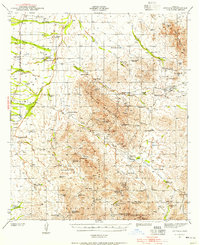 1941 Arivaca1956 Print · USGSIn the early 1940s, this southern Arizona cattle and mining district centered around Arivaca and its surrounding family ranches. Trace the legacy of desert prospecting at the Las Guijas Mine or locate historic homesteads like Canoa Ranch and Montana Ranch.2 unique versions available
 - 1943 Map of Arivaca
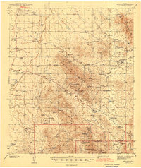 1943 Arivaca1943 Print · USGSIn the early 1940s, this pocket of Pima County was a hub of hard-rock mining and cattle ranching. Researchers can trace family history through sites like Arivaca Ranch, find a lonely Cemetery, or locate dozens of mines including the Las Guijas Mine and Ajax Mine.3 unique versions available
End of results
Showing maps 1-2 of 2
Top cities near Puertocito
Frequently asked questions
- What are the different types of historical maps available for Puertocito?
- What is the oldest map of Puertocito?
- Where can I purchase historical maps of Puertocito for my home or office?
- Where can I download high-res historical maps of Puertocito?
- Are there historical topographic maps available for Puertocito?
- Is there historical aerial imagery available for Puertocito?
- Where are historical maps of Puertocito sourced from?