
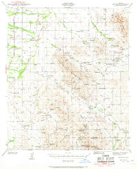
1941 Map of Arivaca
USGS Topo · Published 1956About this map
Las Guijas Mountains dominate this high-desert landscape in southern Arizona, where a sparse network of cattle ranches and hard-rock mines defined the local economy during the early 1940s. The settlement of Arivaca serves as the focal point, situated near the confluence of Arivaca Creek and Puertocito Wash. This era shows a transition in the mining industry, with several major operations such as the Liberty Mine, Colorado Clark Mine, and San Luis Mine already listed as abandoned by the time of the survey.
Find a feature on this map
51 named features on this map. Tap any name to fly to it.
Don’t see what you’re looking for? This feature index may not catch every label — zoom into the map to look around manually.
Map Details
Editions of this 1941 Arivaca Map
2 editions found
Other maps of this area

1920 · Arivaca
USGS Topo · 1:125,000

1921 · Old Glory
USGS Topo · 1:125,000

1925 · Samaniego Peak
USGS Topo · 1:62,500

1939 · Twin Buttes
USGS Topo · 1:62,500

1939 · Tubac
USGS Topo · 1:62,500

1940 · Palo Alto Ranch
USGS Topo · 1:62,500

1941 · Presumido Peak
USGS Topo · 1:62,500

1941 · Twin Buttes
USGS Topo · 1:62,500

1941 · Baboquivari Peak
USGS Topo · 1:62,500

1942 · Ruby
USGS Topo · 1:62,500