
1939 Map of Twin Buttes
USGS Topo · Published 1939About this map
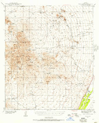
The high-desert terrain of the Sierrita Mountains dominates this 1930s survey, revealing a landscape defined by cattle ranching and mining. Prominent peaks such as Samaniego Pk and Keystone Pk loom over a network of canyons, including Fresnal Canyon and White House Canyon. Human settlement is centered around remote outposts like McGee Ranch, which is served by the nearby McGee School, and several other family operations such as Pino Blanco Ranch and Harris Ranch. The map captures the industrial character of the era through the San Xavier mine area and the namesake Twin Buttes settlement.
Find a feature on this map
42 named features on this map. Tap any name to fly to it.
Don’t see what you’re looking for? This feature index may not catch every label — zoom into the map to look around manually.
Map Details
Editions of this 1939 Twin Buttes Map
2 editions found
Other maps of this area

1904 · Patagonia
USGS Topo · 1:125,000

1904 · Tucson
USGS Topo · 1:125,000

1905 · Patagonia
USGS Topo · 1:125,000

1905 · Tucson
USGS Topo · 1:125,000

1920 · Arivaca
USGS Topo · 1:125,000

1922 · Agus Caliente
USGS Topo · 1:62,500

1925 · Samaniego Peak
USGS Topo · 1:62,500

1925 · San Xavier
USGS Topo · 1:62,500

1926 · Helvetia
USGS Topo · 1:62,500

1934 · Tucson Mountains
USGS Topo · 1:125,000