1990s Maps of Rowood, Arizona
Explore 2 historic maps of Rowood from the 1990s. These maps offer a rare glimpse into what life looked like during the 1990s — showing old roads, neighborhoods, homes, and landmarks that have changed or disappeared over time.
Whether you're researching your family's past, planning a metal detecting trip, or studying how Rowood's landscape evolved across the 1990s, these high-resolution maps are a powerful tool for exploring the history of this region.
- Focus on a specific era: All maps on this page are from the 1990s, giving you a focused view of this time period.
- See what’s changed: Compare century-old streets, trails, and buildings to today's modern landscape using overlays and satellite layers.
- Research with precision: Use these maps for genealogy, historical research, land use analysis, or educational projects.
- View, download, or print: Maps are fully viewable online in high resolution, and can be downloaded or printed for your own records.
Start exploring Rowood's history through authentic maps from the 1990s. This is your window into the past.
Rowood, AZ maps
(2)- 1990 Map of Ajo South, 1991 Print
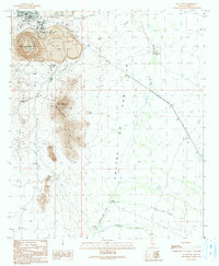 1990 Ajo South1991 Print · USGSIn the Sonoran Desert during the early nineties, the copper mining industry and rugged mountain topography define the landscape south of the town center. Researchers can trace the massive New Cornelia Mine and find landmarks like Locomotive Rock or the Curley Sch.
 - 1996 Map of Ajo South, 2000 Print
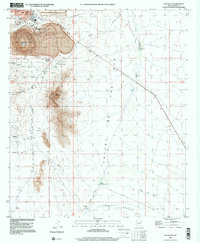 1996 Ajo South2000 Print · USGSSouthern Pima County appears in the mid-1990s as a landscape defined by massive industrial extraction and desert isolation. Researchers can trace the massive New Cornelia Mine works, find the local High Sch in Ajo, and locate landmarks like Locomotive Rock.
End of results
Showing maps 1-2 of 2
Top cities near Rowood
Frequently asked questions
- What are the different types of historical maps available for Rowood?
- What is the oldest map of Rowood?
- Where can I purchase historical maps of Rowood for my home or office?
- Where can I download high-res historical maps of Rowood?
- Are there historical topographic maps available for Rowood?
- Is there historical aerial imagery available for Rowood?
- Where are historical maps of Rowood sourced from?