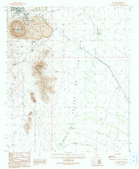
1990 Map of Ajo South
USGS Topo · Published 1991About this map
The New Cornelia Mine dominates the northern landscape of this region, a massive open-pit operation defined by its extensive Mine Dump, Concentrator Hill, and the South Dam Tailings Pond. This industrial footprint sits immediately south of Ajo, where the Curley Sch serves as a central landmark for the town's residential core. Beyond the mine's edge, the terrain shifts abruptly into the jagged peaks of the Little Ajo Mountains, featuring distinctive formations like Locomotive Rock and the high summit of Black Mountain. To the east and south, the topography flattens into The Ajo Valley, a desert expanse marked by ephemeral watercourses such as Cuerda de Leña and Gunsight Wash. The presence of numerous Check Dams and livestock watering points like Eberling Tank reveals the efforts to manage scarce water resources in this arid Pima County environment.
Find a feature on this map
23 named features on this map. Tap any name to fly to it.
Don’t see what you’re looking for? This feature index may not catch every label — zoom into the map to look around manually.
Map Details
Editions of this 1990 Ajo South Map
This is the sole edition of this map. No revisions or reprints were ever made.
Other maps of this area

1932 · Ajo
USGS Topo · 1:62,500

1934 · Ajo
USGS Topo · 1:62,500

1953 · Ajo
USGS Topo · 1:250,000

1957 · Ajo
USGS Topo · 1:250,000

1958 · Ajo
USGS Topo · 1:250,000

1962 · Ajo
USGS Topo · 1:250,000

1963 · Ajo
USGS Topo · 1:250,000

1963 · Ajo
USGS Topo · 1:62,500

1963 · Sikort Chuapo Mts
USGS Topo · 1:62,500

1963 · Mt. Ajo
USGS Topo · 1:62,500