1990s Maps of Kaihon Kug, Sells
Explore 2 historic maps of Kaihon Kug from the 1990s. These maps offer a rare glimpse into what life looked like during the 1990s — showing old roads, neighborhoods, homes, and landmarks that have changed or disappeared over time.
Whether you're researching your family's past, planning a metal detecting trip, or studying how Kaihon Kug's landscape evolved across the 1990s, these high-resolution maps are a powerful tool for exploring the history of this region.
- Focus on a specific era: All maps on this page are from the 1990s, giving you a focused view of this time period.
- See what’s changed: Compare century-old streets, trails, and buildings to today's modern landscape using overlays and satellite layers.
- Research with precision: Use these maps for genealogy, historical research, land use analysis, or educational projects.
- View, download, or print: Maps are fully viewable online in high resolution, and can be downloaded or printed for your own records.
Start exploring Kaihon Kug's history through authentic maps from the 1990s. This is your window into the past.
Kaihon Kug, Sells maps
(2)- 1990 Map of Vainom Kug
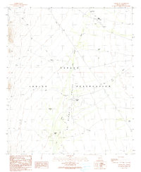 1990 Vainom Kug1990 Print · USGSThe Sonoran desert landscape of the Papago Indian Reservation is captured here in the late twentieth century. Genealogists and desert researchers can trace remote sites like Vainom Kug, the Old Quijotoa Well (Dry), and the archaeological Kui Tatk (Site).
 - 1996 Map of Vainom Kug, 2002 Print
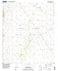 1996 Vainom Kug2002 Print · USGSThe Tohono O'odham Reservation in the late nineties is a landscape shaped by desert washes and vital water infrastructure. Researchers can trace remote settlements like Vainom Kug and Kaihon Kug, alongside scattered landmarks such as Old Quijotoa Well and Francis Tank.
End of results
Showing maps 1-2 of 2
Frequently asked questions
- What are the different types of historical maps available for Kaihon Kug?
- What is the oldest map of Kaihon Kug?
- Where can I purchase historical maps of Kaihon Kug for my home or office?
- Where can I download high-res historical maps of Kaihon Kug?
- Are there historical topographic maps available for Kaihon Kug?
- Is there historical aerial imagery available for Kaihon Kug?
- Where are historical maps of Kaihon Kug sourced from?