1990s Maps of Three Points, Arizona
Explore 3 historic maps of Three Points from the 1990s. These maps offer a rare glimpse into what life looked like during the 1990s — showing old roads, neighborhoods, homes, and landmarks that have changed or disappeared over time.
Whether you're researching your family's past, planning a metal detecting trip, or studying how Three Points's landscape evolved across the 1990s, these high-resolution maps are a powerful tool for exploring the history of this region.
- Focus on a specific era: All maps on this page are from the 1990s, giving you a focused view of this time period.
- See what’s changed: Compare century-old streets, trails, and buildings to today's modern landscape using overlays and satellite layers.
- Research with precision: Use these maps for genealogy, historical research, land use analysis, or educational projects.
- View, download, or print: Maps are fully viewable online in high resolution, and can be downloaded or printed for your own records.
Start exploring Three Points's history through authentic maps from the 1990s. This is your window into the past.
Three Points, AZ maps
(3)- 1992 Map of Three Points, 1995 Print
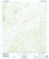 1992 Three Points1995 Print · USGSThe desert crossroads of Pima County come into focus during the early nineties as residential grids began to meet traditional ranch lands. Researchers can trace the development of the Diamond Bell Ranch Road area or locate rural landmarks like Robles Junction and the Corner Windmill.
 - 1994 Map of Silver Bell Mountains
 1994 Silver Bell Mountains1994 Print · USGSSouthern Arizona in the mid-nineties shows a land of transition between desert wilderness, tribal lands, and the growing Tucson suburbs. Genealogists and historians can trace settlements like San Luis and Ko Vaya, or follow the industrial legacy of the Silver Bell Mine.2 unique versions available
 - 1996 Map of Three Points, 2002 Print
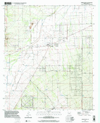 1996 Three Points2002 Print · USGSThree Points and Robles Junction are seen here in the late twentieth century, situated at a vital crossroads in the Pima County desert. Genealogists and local historians can trace ranching infrastructure and early neighborhood layouts along Diamond Bell Ranch Road, Guy Street, and Santa Teresa Well.
End of results
Showing maps 1-3 of 3
Frequently asked questions
- What are the different types of historical maps available for Three Points?
- What is the oldest map of Three Points?
- Where can I purchase historical maps of Three Points for my home or office?
- Where can I download high-res historical maps of Three Points?
- Are there historical topographic maps available for Three Points?
- Is there historical aerial imagery available for Three Points?
- Where are historical maps of Three Points sourced from?