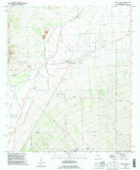
1992 Map of Three Points
USGS Topo · Published 1995About this map
Three Points and Robles Junction anchor this desert landscape at the intersection of critical transit routes in Pima County. The terrain is defined by the broad drainage patterns of Brawley Wash and Mendoza Wash, which cut through the alluvial plains between the Roskruge Mountains to the west and the Sierrita Mountains to the southeast. The 1990s layout reflects a transition from traditional ranching and utility infrastructure toward residential development, particularly evident in the grid of streets south of Diamond Bell Ranch Road, including Vance Blvd and Barron Blvd. Rural water management remains central to the area's utility, marked by numerous cattle tanks and wells such as Javelina Tank, San Juan Tank, and the San Juan Well. Industrial and recreational footprints are also visible, from the Firing Range near the western foothills to the Corner Windmill and various gravel pits that served the region's infrastructure needs.
Find a feature on this map
34 named features on this map. Tap any name to fly to it.
Don’t see what you’re looking for? This feature index may not catch every label — zoom into the map to look around manually.
Map Details
Editions of this 1992 Three Points Map
This is the sole edition of this map. No revisions or reprints were ever made.
Other maps of this area

1920 · Arivaca
USGS Topo · 1:125,000

1925 · Samaniego Peak
USGS Topo · 1:62,500

1925 · San Xavier
USGS Topo · 1:62,500

1934 · Tucson Mountains
USGS Topo · 1:125,000

1939 · Twin Buttes
USGS Topo · 1:62,500

1940 · Palo Alto Ranch
USGS Topo · 1:62,500

1941 · Twin Buttes
USGS Topo · 1:62,500

1941 · Cocoraque Butte
USGS Topo · 1:62,500

1943 · Cocoraque Butte
USGS Topo · 1:62,500

1943 · Palo Alto Ranch
USGS Topo · 1:62,500