1970s Maps of Apache Junction, Arizona
Explore 2 historic maps of Apache Junction from the 1970s. These maps offer a rare glimpse into what life looked like during the 1970s — showing old roads, neighborhoods, homes, and landmarks that have changed or disappeared over time.
Whether you're researching your family's past, planning a metal detecting trip, or studying how Apache Junction's landscape evolved across the 1970s, these high-resolution maps are a powerful tool for exploring the history of this region.
- Focus on a specific era: All maps on this page are from the 1970s, giving you a focused view of this time period.
- See what’s changed: Compare century-old streets, trails, and buildings to today's modern landscape using overlays and satellite layers.
- Research with precision: Use these maps for genealogy, historical research, land use analysis, or educational projects.
- View, download, or print: Maps are fully viewable online in high resolution, and can be downloaded or printed for your own records.
Start exploring Apache Junction's history through authentic maps from the 1970s. This is your window into the past.
Apache Junction, AZ maps
(2)- 1971 Map of Apache Junction, 1972 Print
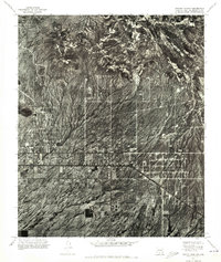 1971 Apache Junction1972 Print · USGSApache Junction emerges from the desert floor in the early seventies, shown here in a detailed aerial orthophotomosaic. Researchers can trace the mid-century street grid and early development patterns of Apache Junction against the untamed desert terrain.
 - 1971 Map of Desert Well, 1972 Print
 1971 Desert Well1972 Print · USGSIn the early 1970s, the landscape around Pinal and Maricopa counties was a mix of military testing and expanding desert agriculture. Researchers can trace the layout of the Desert Proving Grounds and the runway at Rittenhouse Air Force Auxiliary Field.
End of results
Showing maps 1-2 of 2
Top cities near Apache Junction
- Mesa historical maps
- Chandler historical maps
- Gilbert historical maps
- San Tan Valley historical maps
- Queen Creek historical maps
- Fountain Hills historical maps
Top neighborhoods of Apache Junction
- Palm Springs historical maps
- Shiprock RV Resort historical maps
- Wickiup Home Community historical maps
- Arizona Sleets historical maps
- Sierra Leone historical maps
- Apache Dream historical maps
See more
Frequently asked questions
- What are the different types of historical maps available for Apache Junction?
- What is the oldest map of Apache Junction?
- Where can I purchase historical maps of Apache Junction for my home or office?
- Where can I download high-res historical maps of Apache Junction?
- Are there historical topographic maps available for Apache Junction?
- Is there historical aerial imagery available for Apache Junction?
- Where are historical maps of Apache Junction sourced from?