Old Maps of Fountain Hills, Arizona
Explore 39 old maps of Fountain Hills, spanning from 1904 to today. These high-resolution historic maps reveal how streets, neighborhoods, landmarks, and natural features evolved over time — perfect for genealogy, metal detecting, research, and local history exploration.
What you can do with these maps:
- See how Fountain Hills changed over time: Compare historical maps to modern-day views to trace roads, homesites, rail lines & more.
- View detailed metadata: Each map includes creators, publishers, year, scale, and archive source.
- Overlay maps with satellite & LiDAR: Visualize the past alongside modern tools to explore terrain & human change.
- Trusted historical sources: Maps sourced from the USGS, Library of Congress, and other archives.
- Access maps your way: View online, download high-res files, or order prints for personal or research use.
Start exploring old maps of Fountain Hills to uncover forgotten places, hidden landmarks, and the deep history beneath your feet.
Fountain Hills, AZ maps
(39)- 1904 Map of Camelback
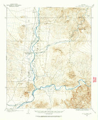
 1904 Camelback1904 Print · USGSMaricopa County is captured at the dawn of the twentieth century, showing a desert landscape before the rise of the Phoenix suburbs. Researchers can trace the foundational Arizona Canal and early landmarks like Camelback Mtn and Thompson Pk.
 - 1904 Map of Ft. McDowell, 1960 Print
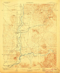
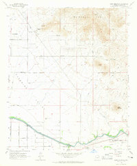
 1904 Ft. McDowell1960 Print · USGSMaricopa County's river valleys and early ranching outposts are captured here at the turn of the century. Genealogists and historians can locate early homesteads like Asher's Ranch and the site of the Limekiln near the Salt River.
 - 1906 Map of Camelsback
 1906 Camelsback1906 Print · USGSArizona's high desert near Phoenix is captured here at the turn of the century, when the landscape was defined by mountain ranges and early water infrastructure. Genealogists and historians can trace the paths of the Old Verde Canal and the Arizona Canal or locate landmarks like Thompson Pk and Mountain Spring.3 unique versions available
 - 1906 Map of Ft. McDowell
 1906 Ft. McDowell1906 Print · USGSMaricopa County's river valleys and desert foothills were defined by a network of ranching homesteads and tribal lands in the early 1900s. Researchers can trace the early foundations of Arizona water management near the Arizona Dam and locate family outposts like Otero's Ranch and Stewarts Ranch.3 unique versions available
 - 1930 Map of Cave Creek, 1959 Print
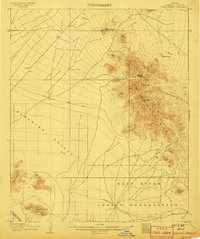
 1930 Cave Creek1959 Print · USGSThe Cave Creek and Verde River backcountry comes alive in this survey from the era of guest ranches and remote outposts. Researchers can locate early family homesteads like Lewis Ranch, trace the route to the Mormon Girl Mine, or find the original Spur Cross Dude Ranch.2 unique versions available
 - 1939 Map of Cave Creek
 1939 Cave Creek1939 Print · USGSThe Cave Creek area in the late thirties is a landscape of working cattle ranches and early desert tourism. Genealogists and historians can trace family-named outposts like Sears Kay Ranch and Browns Ranch or the historic Mormon Girl Mine.3 unique versions available
 - 1954 Map of Mesa, 1968 Print
 1954 Mesa1968 Print · USGSCentral Arizona in the mid-fifties reveals the rapid growth of the Valley of the Sun alongside the deep-rooted mining districts of the eastern mountains. Genealogists and researchers can trace the expansion of Mesa and Chandler or locate legacy operations at Inspiration Mine and the Magma Arizona railroad.4 unique versions available
 - 1957 Map of Mesa
 1957 Mesa1957 Print · USGSCentral Arizona's desert valleys and high-mountain mining districts come alive in the mid-fifties. Researchers can trace the early layout of Mesa and Phoenix or locate remote sites like Inspiration Mine and Arizona State College.
 - 1958 Map of Mesa
 1958 Mesa1958 Print · USGSMid-century Arizona comes alive in this survey of the valley and high desert, where urban growth begins to transform the landscape. Genealogists and researchers can trace the rail-and-mine economy through Inspiration Mine and old stops like Rittenhouse and Magma.
 - 1960 Map of Mesa
 1960 Mesa1960 Print · USGSThe Salt River Valley and Superstition wilderness are captured here during a era of rapid post-war growth. Researchers can trace the mid-century footprints of Williams AF Base and Arizona State College or locate the deep-rock shafts of the Old Dominion Mine and Magma Mine.
 - 1964 Map of Mesa
 1964 Mesa1964 Print · USGSCentral Arizona in the mid-1960s reveals a landscape defined by rapid desert urbanization and a massive copper mining industry. Genealogists and historians can trace the growth of Phoenix or explore the mining camps and operations at Miami Mine and Magma Mine.
 - 1964 Map of Granite Reef Dam, 1965 Print
 1964 Granite Reef Dam1965 Print · USGSThe confluence of the Salt and Verde rivers is documented here in the mid-1960s, showing the vital irrigation infrastructure of the burgeoning Phoenix region. Researchers can trace historical sites like the Jim Hart Memorial Monument, the P Bar Ranch, and the early layout of the Arizona Canal.3 unique versions available
 - 1964 Map of Sawik Mountain, 1965 Print
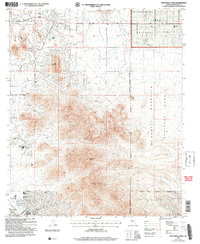
 1964 Sawik Mountain1965 Print · USGSNortheastern Scottsdale and Paradise Valley are captured here in the mid-sixties, just as suburban roads began to push into the desert. Researchers can trace early landmarks like Taliesin West, ancient Petroglyphs, and the Beeline Dragway.5 unique versions available
 - 1964 Map of Fort McDowell, 1965 Print
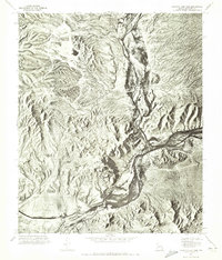
 1964 Fort McDowell1965 Print · USGSMaricopa County's desert riparian corridor comes to life in the mid-sixties, centered on the irrigation and settlement along the Verde River. Genealogists and local historians can locate the Fort McDowell community, the Box Bar Ranch, and a local Cem.4 unique versions available
 - 1965 Map of McDowell Peak, 1967 Print
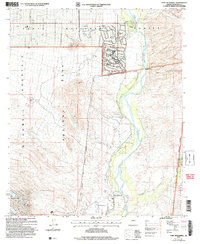
 1965 McDowell Peak1967 Print · USGSThe McDowell Mountains and northern Paradise Valley appear in the mid-1960s before widespread suburban development reached the peaks. Trace the early Scottsdale Corporate Boundary near landmarks like Reata Pass and the Dixie Mine.6 unique versions available
 - 1971 Map of McDowell Peak, 1972 Print
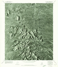 1971 McDowell Peak1972 Print · USGSThe Maricopa County desert is captured in high-detail aerial photography in the early seventies, just as the region began its modern growth. Researchers can study the untouched natural topography surrounding Mc Dowell Peak and the distinctive granite formations of Pinnacle Peak.2 unique versions available
 - 1971 Map of Sawik Mountain, 1972 Print
 1971 Sawik Mountain1972 Print · USGSMaricopa County's desert interface is captured in the early seventies, showcasing the dramatic meeting of mountain peaks and irrigation. Genealogists and historians can trace the course of the Arizona Canal past the foot of Sawik Mtn and the McDowell Mts.
 - 1971 Map of Fort McDowell, 1972 Print
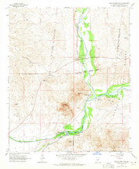
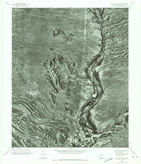 1971 Fort McDowell1972 Print · USGSMaricopa County is captured during the early 1970s in this detailed aerial survey of the desert landscape and river bottomlands. Researchers can trace the layout of Fort McDowell and locate landmarks like Lousley Hill and the winding Verde River.
 - 1971 Map of Granite Reef Dam, 1972 Print
 1971 Granite Reef Dam1972 Print · USGSMaricopa County's desert hydrology is revealed in the early seventies at the critical meeting of two major rivers. Researchers can trace the water distribution at Granite Reef Dam and study the terrain surrounding Mount Mc Dowell.
 - 1994 Map of Theodore Roosevelt Lake, 1995 Print
 1994 Theodore Roosevelt Lake1995 Print · USGSCentral Arizona in the early nineties reveals the sprawling growth of the Valley of the Sun against the high desert wilderness. Researchers can trace the development of Scottsdale and Carefree or locate remote outposts like Sunflower and Punkin Center near the Mazatzal Wilderness.3 unique versions available
 - 2004 Map of Granite Reef Dam, 2007 Print
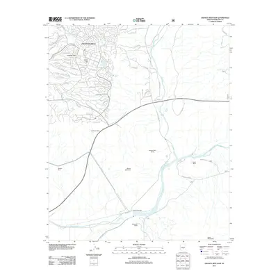
 2004 Granite Reef Dam2007 Print · USGSThe confluence of the Salt and Verde rivers is documented here in the early 2000s, showing a landscape defined by water engineering and tribal lands. Trace the path of the Arizona Canal from the Granite Reef Dam or locate the Jim Hart Memorial Monument.
 - 2004 Map of Fort McDowell, 2007 Print
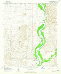
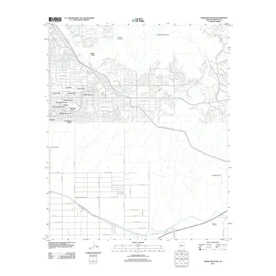
 2004 Fort McDowell2007 Print · USGSMaricopa County's desert river valley is captured here in the early 2000s as suburban expansion met tribal and protected lands. Trace the Verde River through the Fort McDowell Indian Reservation Boundary past Rio Verde Estates and the historic Fort McDowell Site.
 - 2004 Map of McDowell Peak, 2007 Print
 2004 McDowell Peak2007 Print · USGSThe McDowell Mountains and Scottsdale foothills are captured here during a period of rapid development and recreational expansion. You can trace the proximity of newer sites like the Arabian Library to older landmarks such as Dixie Mine and Reata Pass.
 - 2011 Map of Sawik Mountain, 2011 Print
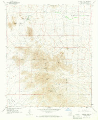
 2011 Sawik Mountain2011 Print · USGSCovers Fountain Hills, including Scottsdale, Maricopa County, and other nearby areas
 - 2011 Map of Granite Reef Dam, 2011 Print
 2011 Granite Reef Dam2011 Print · USGSCovers Fountain Hills, including Mesa, Maricopa County, and other nearby areas
Showing maps 1-25 of 39
Top cities near Fountain Hills
- Phoenix historical maps
- Mesa historical maps
- Scottsdale historical maps
- Gilbert historical maps
- Tempe historical maps
- Apache Junction historical maps
See more
Top neighborhoods of Fountain Hills
Frequently asked questions
- What are the different types of historical maps available for Fountain Hills?
- What is the oldest map of Fountain Hills?
- Where can I purchase historical maps of Fountain Hills for my home or office?
- Where can I download high-res historical maps of Fountain Hills?
- Are there historical topographic maps available for Fountain Hills?
- Is there historical aerial imagery available for Fountain Hills?
- Where are historical maps of Fountain Hills sourced from?