1960s Maps of Fountain Hills, Arizona
Explore 6 historic maps of Fountain Hills from the 1960s. These maps offer a rare glimpse into what life looked like during the 1960s — showing old roads, neighborhoods, homes, and landmarks that have changed or disappeared over time.
Whether you're researching your family's past, planning a metal detecting trip, or studying how Fountain Hills's landscape evolved across the 1960s, these high-resolution maps are a powerful tool for exploring the history of this region.
- Focus on a specific era: All maps on this page are from the 1960s, giving you a focused view of this time period.
- See what’s changed: Compare century-old streets, trails, and buildings to today's modern landscape using overlays and satellite layers.
- Research with precision: Use these maps for genealogy, historical research, land use analysis, or educational projects.
- View, download, or print: Maps are fully viewable online in high resolution, and can be downloaded or printed for your own records.
Start exploring Fountain Hills's history through authentic maps from the 1960s. This is your window into the past.
Fountain Hills, AZ maps
(6)- 1960 Map of Mesa
 1960 Mesa1960 Print · USGSThe Salt River Valley and Superstition wilderness are captured here during a era of rapid post-war growth. Researchers can trace the mid-century footprints of Williams AF Base and Arizona State College or locate the deep-rock shafts of the Old Dominion Mine and Magma Mine.
 - 1964 Map of Mesa
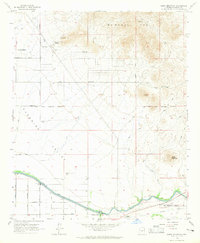
 1964 Mesa1964 Print · USGSCentral Arizona in the mid-1960s reveals a landscape defined by rapid desert urbanization and a massive copper mining industry. Genealogists and historians can trace the growth of Phoenix or explore the mining camps and operations at Miami Mine and Magma Mine.
 - 1964 Map of Granite Reef Dam, 1965 Print
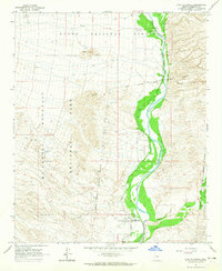
 1964 Granite Reef Dam1965 Print · USGSThe confluence of the Salt and Verde rivers is documented here in the mid-1960s, showing the vital irrigation infrastructure of the burgeoning Phoenix region. Researchers can trace historical sites like the Jim Hart Memorial Monument, the P Bar Ranch, and the early layout of the Arizona Canal.3 unique versions available
 - 1964 Map of Sawik Mountain, 1965 Print
 1964 Sawik Mountain1965 Print · USGSNortheastern Scottsdale and Paradise Valley are captured here in the mid-sixties, just as suburban roads began to push into the desert. Researchers can trace early landmarks like Taliesin West, ancient Petroglyphs, and the Beeline Dragway.5 unique versions available
 - 1964 Map of Fort McDowell, 1965 Print
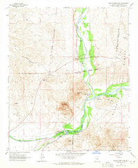
 1964 Fort McDowell1965 Print · USGSMaricopa County's desert riparian corridor comes to life in the mid-sixties, centered on the irrigation and settlement along the Verde River. Genealogists and local historians can locate the Fort McDowell community, the Box Bar Ranch, and a local Cem.4 unique versions available
 - 1965 Map of McDowell Peak, 1967 Print
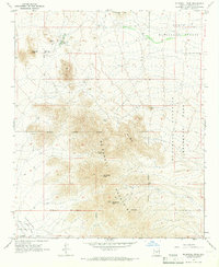 1965 McDowell Peak1967 Print · USGSThe McDowell Mountains and northern Paradise Valley appear in the mid-1960s before widespread suburban development reached the peaks. Trace the early Scottsdale Corporate Boundary near landmarks like Reata Pass and the Dixie Mine.6 unique versions available
End of results
Showing maps 1-6 of 6
Top cities near Fountain Hills
- Phoenix historical maps
- Mesa historical maps
- Scottsdale historical maps
- Gilbert historical maps
- Tempe historical maps
- Apache Junction historical maps
See more
Top neighborhoods of Fountain Hills
Frequently asked questions
- What are the different types of historical maps available for Fountain Hills?
- What is the oldest map of Fountain Hills?
- Where can I purchase historical maps of Fountain Hills for my home or office?
- Where can I download high-res historical maps of Fountain Hills?
- Are there historical topographic maps available for Fountain Hills?
- Is there historical aerial imagery available for Fountain Hills?
- Where are historical maps of Fountain Hills sourced from?