1970s Maps of Fountain Hills, Arizona
Explore 4 historic maps of Fountain Hills from the 1970s. These maps offer a rare glimpse into what life looked like during the 1970s — showing old roads, neighborhoods, homes, and landmarks that have changed or disappeared over time.
Whether you're researching your family's past, planning a metal detecting trip, or studying how Fountain Hills's landscape evolved across the 1970s, these high-resolution maps are a powerful tool for exploring the history of this region.
- Focus on a specific era: All maps on this page are from the 1970s, giving you a focused view of this time period.
- See what’s changed: Compare century-old streets, trails, and buildings to today's modern landscape using overlays and satellite layers.
- Research with precision: Use these maps for genealogy, historical research, land use analysis, or educational projects.
- View, download, or print: Maps are fully viewable online in high resolution, and can be downloaded or printed for your own records.
Start exploring Fountain Hills's history through authentic maps from the 1970s. This is your window into the past.
Fountain Hills, AZ maps
(4)- 1971 Map of McDowell Peak, 1972 Print
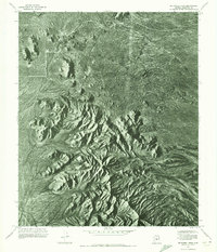 1971 McDowell Peak1972 Print · USGSThe Maricopa County desert is captured in high-detail aerial photography in the early seventies, just as the region began its modern growth. Researchers can study the untouched natural topography surrounding Mc Dowell Peak and the distinctive granite formations of Pinnacle Peak.2 unique versions available
 - 1971 Map of Sawik Mountain, 1972 Print
 1971 Sawik Mountain1972 Print · USGSMaricopa County's desert interface is captured in the early seventies, showcasing the dramatic meeting of mountain peaks and irrigation. Genealogists and historians can trace the course of the Arizona Canal past the foot of Sawik Mtn and the McDowell Mts.
 - 1971 Map of Fort McDowell, 1972 Print
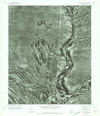 1971 Fort McDowell1972 Print · USGSMaricopa County is captured during the early 1970s in this detailed aerial survey of the desert landscape and river bottomlands. Researchers can trace the layout of Fort McDowell and locate landmarks like Lousley Hill and the winding Verde River.
 - 1971 Map of Granite Reef Dam, 1972 Print
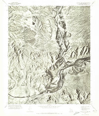 1971 Granite Reef Dam1972 Print · USGSMaricopa County's desert hydrology is revealed in the early seventies at the critical meeting of two major rivers. Researchers can trace the water distribution at Granite Reef Dam and study the terrain surrounding Mount Mc Dowell.
End of results
Showing maps 1-4 of 4
Top cities near Fountain Hills
- Phoenix historical maps
- Mesa historical maps
- Scottsdale historical maps
- Gilbert historical maps
- Tempe historical maps
- Apache Junction historical maps
See more
Top neighborhoods of Fountain Hills
Frequently asked questions
- What are the different types of historical maps available for Fountain Hills?
- What is the oldest map of Fountain Hills?
- Where can I purchase historical maps of Fountain Hills for my home or office?
- Where can I download high-res historical maps of Fountain Hills?
- Are there historical topographic maps available for Fountain Hills?
- Is there historical aerial imagery available for Fountain Hills?
- Where are historical maps of Fountain Hills sourced from?