1940s Maps of Dudleyville, Arizona
Explore 2 historic maps of Dudleyville from the 1940s. These maps offer a rare glimpse into what life looked like during the 1940s — showing old roads, neighborhoods, homes, and landmarks that have changed or disappeared over time.
Whether you're researching your family's past, planning a metal detecting trip, or studying how Dudleyville's landscape evolved across the 1940s, these high-resolution maps are a powerful tool for exploring the history of this region.
- Focus on a specific era: All maps on this page are from the 1940s, giving you a focused view of this time period.
- See what’s changed: Compare century-old streets, trails, and buildings to today's modern landscape using overlays and satellite layers.
- Research with precision: Use these maps for genealogy, historical research, land use analysis, or educational projects.
- View, download, or print: Maps are fully viewable online in high resolution, and can be downloaded or printed for your own records.
Start exploring Dudleyville's history through authentic maps from the 1940s. This is your window into the past.
Dudleyville, AZ maps
(2)- 1949 Map of Holy Joe Peak, 1952 Print
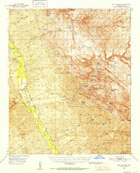 1949 Holy Joe Peak1952 Print · USGSSoutheast Arizona in the late 1940s reveals a high-desert ranching landscape shaped by the San Pedro River and the rugged cuts of Aravaipa Canyon. Researchers can trace the path of the Old Camp Grant Military Road and locate family landmarks like Eskimazene Ranch or the PZ Ranch.2 unique versions available
 - 1949 Map of Saddle Mtn., 1961 Print
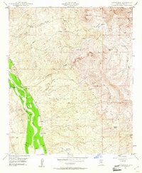 1949 Saddle Mtn.1961 Print · USGSPinal County ranching and mining operations are captured here during the late 1940s as the desert landscape remained largely untamed. Researchers can locate family-named sites like Eskimazene Ranch, the Finch Sch (Aban'd), and the southern Gypsum Mines.4 unique versions available
End of results
Showing maps 1-2 of 2
Top cities near Dudleyville
Frequently asked questions
- What are the different types of historical maps available for Dudleyville?
- What is the oldest map of Dudleyville?
- Where can I purchase historical maps of Dudleyville for my home or office?
- Where can I download high-res historical maps of Dudleyville?
- Are there historical topographic maps available for Dudleyville?
- Is there historical aerial imagery available for Dudleyville?
- Where are historical maps of Dudleyville sourced from?