1960s Maps of Florence, Arizona
Explore 9 historic maps of Florence from the 1960s. These maps offer a rare glimpse into what life looked like during the 1960s — showing old roads, neighborhoods, homes, and landmarks that have changed or disappeared over time.
Whether you're researching your family's past, planning a metal detecting trip, or studying how Florence's landscape evolved across the 1960s, these high-resolution maps are a powerful tool for exploring the history of this region.
- Focus on a specific era: All maps on this page are from the 1960s, giving you a focused view of this time period.
- See what’s changed: Compare century-old streets, trails, and buildings to today's modern landscape using overlays and satellite layers.
- Research with precision: Use these maps for genealogy, historical research, land use analysis, or educational projects.
- View, download, or print: Maps are fully viewable online in high resolution, and can be downloaded or printed for your own records.
Start exploring Florence's history through authentic maps from the 1960s. This is your window into the past.
Florence, AZ maps
(9)- 1960 Map of Mesa
 1960 Mesa1960 Print · USGSThe Salt River Valley and Superstition wilderness are captured here during a era of rapid post-war growth. Researchers can trace the mid-century footprints of Williams AF Base and Arizona State College or locate the deep-rock shafts of the Old Dominion Mine and Magma Mine.
 - 1962 Map of Tucson
 1962 Tucson1962 Print · USGSSouthern Arizona in the early sixties showcases a landscape defined by burgeoning desert cities and massive military installations. Researchers can trace tribal settlements like Schuchk, legacy mining sites at Silver Bell Mine, and the early footprint of Davis-Monthan Air Force Base.
 - 1964 Map of Tucson
 1964 Tucson1964 Print · USGSSouthern Arizona in the mid-1960s shows a landscape of burgeoning desert cities and industrial-scale copper mining. Researchers can trace the development of Tucson and its outlying mining districts, including the Silver Bell Mine and San Manuel Mine.
 - 1964 Map of Mesa
 1964 Mesa1964 Print · USGSCentral Arizona in the mid-1960s reveals a landscape defined by rapid desert urbanization and a massive copper mining industry. Genealogists and historians can trace the growth of Phoenix or explore the mining camps and operations at Miami Mine and Magma Mine.
 - 1964 Map of Valley Farms, 1965 Print
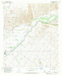
 1964 Valley Farms1965 Print · USGSArizona's desert agriculture is on full display in the 1960s as irrigation canals and rural schools shaped Pinal County. Trace the development of Valley Farms through its local landmarks, including the Kenilworth Sch, Casa Grande Canal, and Sarita Airport.2 unique versions available
 - 1965 Map of Florence, 1967 Print
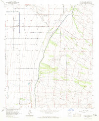
 1965 Florence1967 Print · USGSThe Pinal County seat and its surrounding irrigation network are captured here in the mid-1960s, showing a desert landscape shaped by water and institutions. Genealogists and historians can locate the State Prison, Florence Cemetery, and the site of Adamsville.3 unique versions available
 - 1965 Map of Florence SE, 1967 Print
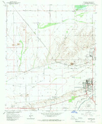
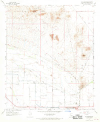
 1965 Florence SE1967 Print · USGSCovers Florence, including Pinal County, United States, and other nearby areas3 unique versions available
 - 1966 Map of Cactus Forest, 1969 Print
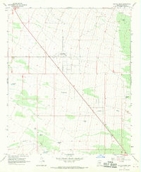 1966 Cactus Forest1969 Print · USGSCactus Forest and the Pinal County desert are captured in the mid-1960s as ranching life met the expanding highway system. Genealogists and local historians can trace named water improvements like Youtsey Tank and Clemans Tank or the small settlement of Paisano.2 unique versions available
 - 1966 Map of Blackwater, 1970 Print
 1966 Blackwater1970 Print · USGSPinal County in the mid-1960s reveals a desert landscape shaped by the Gila River and Indigenous lands. Genealogists and researchers can trace the roads around Blackwater, identify a local Cem, and locate landmarks like Walker Butte or the Southern Pacific line.2 unique versions available
End of results
Showing maps 1-9 of 9
Top cities near Florence
- Mesa historical maps
- San Tan Valley historical maps
- Queen Creek historical maps
- Eloy historical maps
- Coolidge historical maps
Top neighborhoods of Florence
Frequently asked questions
- What are the different types of historical maps available for Florence?
- What is the oldest map of Florence?
- Where can I purchase historical maps of Florence for my home or office?
- Where can I download high-res historical maps of Florence?
- Are there historical topographic maps available for Florence?
- Is there historical aerial imagery available for Florence?
- Where are historical maps of Florence sourced from?