1900-1909 Maps of Florence, Arizona
Explore 3 historic maps of Florence from 1900-1909. These maps offer a rare glimpse into what life looked like during the 1900s — showing old roads, neighborhoods, homes, and landmarks that have changed or disappeared over time.
Whether you're researching your family's past, planning a metal detecting trip, or studying how Florence's landscape evolved across the 1900s, these high-resolution maps are a powerful tool for exploring the history of this region.
- Focus on a specific era: All maps on this page are from the 1900s, giving you a focused view of this time period.
- See what’s changed: Compare century-old streets, trails, and buildings to today's modern landscape using overlays and satellite layers.
- Research with precision: Use these maps for genealogy, historical research, land use analysis, or educational projects.
- View, download, or print: Maps are fully viewable online in high resolution, and can be downloaded or printed for your own records.
Start exploring Florence's history through authentic maps from the 1900s. This is your window into the past.
Florence, AZ maps
(3)- 1900 Map of Florence, 1956 Print
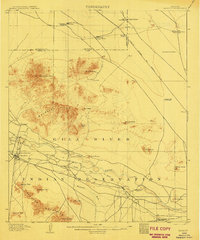
 1900 Florence1956 Print · USGSArizona's mining and ranching frontiers are mapped here at the dawn of the century as the Gila River valley begins its growth. Researchers can trace historic family holdings like Arnett Ranch and early industrial camps at Silver King or the Silver Bell Mine.
 - 1902 Map of Florence
 1902 Florence1902 Print · USGSFlorence and the Gila River valley are captured here at the turn of the century during the peak of early Arizona mining and ranching. Researchers can locate vanished settlements and family sites like Silver King, Adamsville, and the Silver Bell Mine.5 unique versions available
 - 1907 Map of Sacaton
 1907 Sacaton1907 Print · USGSThe Gila River Valley comes alive in this survey from the early 1900s, showing the early infrastructure of the Gila River Indian Reservation. Trace the legacy of desert ranching at Andrada's Ranch or find the early site of Blackwater Chapel.4 unique versions available
End of results
Showing maps 1-3 of 3
Top cities near Florence
- Mesa historical maps
- San Tan Valley historical maps
- Queen Creek historical maps
- Eloy historical maps
- Coolidge historical maps
Top neighborhoods of Florence
Frequently asked questions
- What are the different types of historical maps available for Florence?
- What is the oldest map of Florence?
- Where can I purchase historical maps of Florence for my home or office?
- Where can I download high-res historical maps of Florence?
- Are there historical topographic maps available for Florence?
- Is there historical aerial imagery available for Florence?
- Where are historical maps of Florence sourced from?