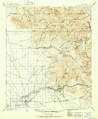
1900 Map of Florence
USGS Topo · Published 1956About this map
Florence and the surrounding desert floor meet the complex canyons of the Superstition Mountains in this early 20th-century survey. The landscape is defined by the heavy presence of the Gila River and the Arizona Eastern railroad, which supported the region's burgeoning mining and agricultural operations. The map documents a rugged interior filled with family ranches, including Tortilla Ranch and Nicholas Ranch, alongside significant industrial sites like the Silver Bell Mine and the mining camp of Silver King.
Find a feature on this map
94 named features on this map. Tap any name to fly to it.
Don’t see what you’re looking for? This feature index may not catch every label — zoom into the map to look around manually.
Map Details
Editions of this 1900 Florence Map
This is the sole edition of this map. No revisions or reprints were ever made.
Historical Maps of Apache Junction Through Time
7 maps found