
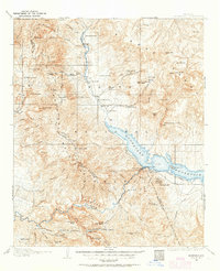
1907 Map of Roosevelt
USGS Topo · Published 1956About this map
The Roosevelt Dam stands as the central engineering marvel of this central Arizona landscape, where the confluence of Tonto Creek and the Salt River creates the expansive Roosevelt Reservoir. Surveyed in the early twentieth century, this map documents the transition from a ranching frontier to a managed watershed. Clustered along the creek bottoms and mountain foothills are numerous family outposts including Clanton's Ranch, Howell's Ranch, and Lockwood Ranch, reflecting the early settlement patterns before the full impact of water reclamation. To the south, the Salt River carves through dramatic geology near Painted Cliffs and Horse Mesa. The territory is bounded by the towering Sierra Ancha and Mazatzal Mountains, while cultural landmarks like the Tonto National Monument and the early community of Roosevelt highlight the intersection of ancient history and modern infrastructure.
Find a feature on this map
86 named features on this map. Tap any name to fly to it.
Don’t see what you’re looking for? This feature index may not catch every label — zoom into the map to look around manually.
Map Details
Editions of this 1907 Roosevelt Map
2 editions found
Other maps of this area

1886 · Holbrook
USGS Topo · 1:250,000

1887 · Verde
USGS Topo · 1:250,000

1892 · Verde
USGS Topo · 1:250,000

1893 · Holbrook
USGS Topo · 1:250,000

1900 · Florence
USGS Topo · 1:125,000

1901 · Globe
USGS Topo · 1:62,500

1902 · Globe
USGS Topo · 1:62,500

1902 · Florence
USGS Topo · 1:125,000

1904 · Desert Well
USGS Topo · 1:62,500

1904 · Ft. McDowell
USGS Topo · 1:62,500