Old Maps of Gila County, Arizona
Explore 691 old maps of Gila County, spanning from 1886 to today. These high-resolution historic maps reveal how streets, neighborhoods, landmarks, and natural features evolved over time — perfect for genealogy, metal detecting, research, and local history exploration.
What you can do with these maps:
- See how Gila County changed over time: Compare historical maps to modern-day views to trace roads, homesites, rail lines & more.
- View detailed metadata: Each map includes creators, publishers, year, scale, and archive source.
- Overlay maps with satellite & LiDAR: Visualize the past alongside modern tools to explore terrain & human change.
- Trusted historical sources: Maps sourced from the USGS, Library of Congress, and other archives.
- Access maps your way: View online, download high-res files, or order prints for personal or research use.
Start exploring old maps of Gila County to uncover forgotten places, hidden landmarks, and the deep history beneath your feet.
Gila County, AZ maps
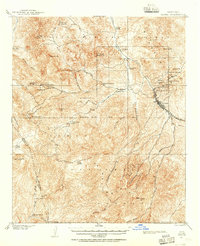
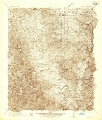
(691)- 1886 Map of Holbrook
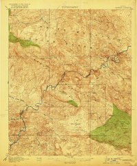
 1886 Holbrook1886 Print · USGSArizona's high desert and the Mogollon Rim frontier are captured here in the late nineteenth century during the height of early pioneer settlement. Trace the growth of river towns like Holbrook and Snowflake or locate remote outposts such as Wilford, Adair, and Heber.
 - 1887 Map of Verde
 1887 Verde1887 Print · USGSCentral Arizona at the height of the territorial era is defined by the military presence at Fort Verde and the ranching settlements below the Mogollon Mesa. Genealogists and researchers can trace the early foundations of Payson, Pine, and Strawberry or locate landmarks like Montezuma Well and Natural Bridge.
 - 1892 Map of Verde
 1892 Verde1892 Print · USGSArizona's territorial frontier is captured in the late nineteenth century as the first ranching and military outposts emerged. Trace the earliest layouts of Payson, Fort Verde, and Strawberry alongside landmarks like Montezuma Well and Natural Bridge.5 unique versions available
 - 1893 Map of Holbrook
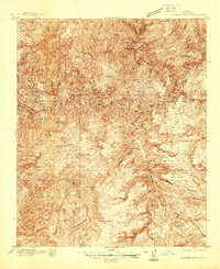
 1893 Holbrook1893 Print · USGSNortheastern Arizona in the 1880s reveals a landscape of nascent ranching towns and deep canyon systems along the high plateau. Genealogists and historians can trace the early footprints of Holbrook, Snowflake, and Showlow as they appeared before the turn of the century.4 unique versions available
 - 1900 Map of Florence, 1956 Print
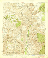
 1900 Florence1956 Print · USGSArizona's mining and ranching frontiers are mapped here at the dawn of the century as the Gila River valley begins its growth. Researchers can trace historic family holdings like Arnett Ranch and early industrial camps at Silver King or the Silver Bell Mine.
 - 1901 Map of Globe, 1955 Print
 1901 Globe1955 Print · USGSThe Arizona copper belt and the mining town of Globe appear here at the turn of the century during a period of intense industrial expansion. Genealogists and historians can trace early family-held outposts like Horrell's Ranch and major operations including the Old Dominion Mine.2 unique versions available
 - 1902 Map of Globe
 1902 Globe1902 Print · USGSThe mining district of Globe is captured here at the height of its early copper boom. Genealogists and historians can trace the workings of the Old Dominion Mine and Black Warrior, or locate family sites like Pinal Ranch.3 unique versions available
 - 1902 Map of Florence
 1902 Florence1902 Print · USGSFlorence and the Gila River valley are captured here at the turn of the century during the peak of early Arizona mining and ranching. Researchers can locate vanished settlements and family sites like Silver King, Adamsville, and the Silver Bell Mine.5 unique versions available
 - 1907 Map of Roosevelt, 1956 Print
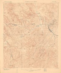
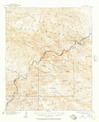
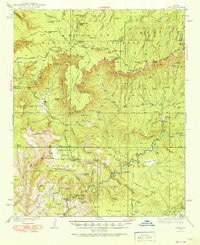
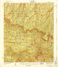
 1907 Roosevelt1956 Print · USGSCentral Arizona at the birth of the reclamation era centers on the engineering of the Roosevelt Dam and the waters of the Salt River. Genealogists and historians can trace numerous early family holdings like Clanton's Ranch, the stage stop at Schells Station, and the remote settlement of Apacheria.2 unique versions available
 - 1909 Map of Four Peaks
 1909 Four Peaks1909 Print · USGSThe central Arizona wilderness at the start of the century reveals a land of isolated ranching outposts and rugged mountain passes. Researchers can trace the early cattle frontier at Sunflower Ranch, find the original Mormon Flats, and locate the historic Schells Station.2 unique versions available
 - 1910 Map of Ray
 1910 Ray1910 Print · USGSArizona's copper country and Gila River basin are captured here at a peak of early industrial expansion. Genealogy researchers can locate early homesteads like Uncle Dan's Ranch and Winkelman's Ranch, alongside the massive Ray Mine and the Phoenix and Eastern R. R. corridor.3 unique versions available
 - 1911 Map of Winkelman, 1957 Print
 1911 Winkelman1957 Print · USGSThe Pinal and Pima County line comes alive in the 1910s, showing a landscape of mining camps and early ranching. Genealogists and historians can trace the foundations of Mammoth and find long-lost sites like the Finch School, Campo Bonito, and the MAMMOTH MINE.
 - 1912 Map of Roosevelt
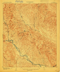
 1912 Roosevelt1912 Print · USGSCentral Arizona is captured here during the transformative years following the completion of the Roosevelt Dam. You can trace early ranching homesteads such as Clines Ranch and Howell's Ranch or locate the site of Schell's Station.4 unique versions available
 - 1913 Map of Winkelman
 1913 Winkelman1913 Print · USGSThe confluence of the Gila and San Pedro rivers in the 1910s reveals a landscape of mining camps and remote ranching outposts. Trace the early industrial footprint of the Mammoth Mine and Oracle or find family landmarks like Finch School and Biddicks Cabin.4 unique versions available
 - 1915 Map of Christmas, 1957 Print
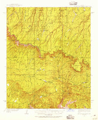
 1915 Christmas1957 Print · USGSThe Gila River canyon and Mescal Mountains are shown here during the peak of early Arizona mining and ranching. Genealogists and historians can trace the foundations of the Christmas settlement, the Arizona Eastern rail line, and remote sites like Mings Ranch or the Lower Coal Field Mine.2 unique versions available
 - 1917 Map of Christmas
 1917 Christmas1917 Print · USGSMining camps and desert ranching take center stage in this Gila County survey conducted just after the turn of the century. Genealogists and historians can trace the early footprint of Christmas and the various mineral works of the region, from the Lee Mine to the Old Mill.3 unique versions available
 - 1922 Map of Chrysotile
 1922 Chrysotile1922 Print · USGSGila County's mining and ranching frontier is documented in the early twenties during a period of rapid reconnaissance mapping. Researchers can locate early outposts and water sources such as McMillanville, Chrysotile, and Ash Spring near the Fort Apache Reservation boundary.
 - 1929 Map of Turret Peak, 1958 Print
 1929 Turret Peak1958 Print · USGSYavapai County ranching and mining reach their peak in the late twenties along the winding Verde River. Researchers can trace the legacy of early families and industrial ventures at the United Arizona Mine, Brown Springs Ranch, and Anchor Ranch.3 unique versions available
 - 1933 Map of Turret Peak
 1933 Turret Peak1933 Print · USGSArizona's central highlands come alive in the 1930s as a land of remote mining claims and isolated ranching outposts. Trace the early copper industry at the Copper Queen Mine and Rosalie Mine, or locate family sites like the Dugan Ranch and Dugas near the Verde River.3 unique versions available
 - 1934 Map of Pine
 1934 Pine1934 Print · USGSIn the mid-1930s, the dramatic Mogollon Rim divided Arizona's high timberlands from the rugged canyon country. Genealogists and historians can trace early mountain life through the Crackerjack Mine, the Natural Bridge, and the Chase Ranch.2 unique versions available
 - 1934 Map of Promontory Butte, 1955 Print
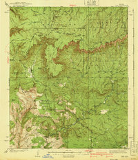
 1934 Promontory Butte1955 Print · USGSThe Mogollon Rim country of Gila and Coconino Counties is captured in the mid-thirties, showcasing a network of remote homesteads and forest service outposts. Trace family history and early mountain life at sites like the Zane Grey Lodge, Haught Sawmill, and the Fred Haught Cabin.
 - 1936 Map of Payson
 1936 Payson1936 Print · USGSThe high-desert ranches and rugged mining claims of Gila County are captured here in the mid-1930s. Genealogists and historians can locate early family homesteads like the Seventy-Six Ranch and remote school sites such as Gisela Sch.3 unique versions available
 - 1937 Map of Diamond Butte
 1937 Diamond Butte1937 Print · USGSGila County ranching and prospecting are documented here in the late 1930s as the high-country landscape remains largely primitive. Researchers can locate remote family landmarks such as Vaughn Ranch, Wilbanks Ranch, and the Spring Creek Mine.3 unique versions available
 - 1939 Map of Promontory Butte
 1939 Promontory Butte1939 Print · USGSArizona's rim country comes alive in the late 1930s, showing the early ranches and forest outposts that predated modern recreation. Trace the locations of historic homesteads like Zane Grey Lodge, the Haught Sawmill, and the Buck Springs Guard Station.3 unique versions available
 - 1940 Map of Pine
 1940 Pine1940 Print · USGSThe northern Arizona highlands are captured here in the mid-1930s, showing the rugged divide of the Mogollon Rim. Local historians can trace early settlements at Pine and Strawberry, along with remote sites like Chase Ranch and the White Mtn Mine.
Showing maps 1-25 of 691
Top cities of Gila County
- Payson historical maps
- Globe historical maps
- San Carlos historical maps
- Star Valley historical maps
- Pine historical maps
- Miami historical maps
See more
Frequently asked questions
- What are the different types of historical maps available for Gila County?
- What is the oldest map of Gila County?
- Where can I purchase historical maps of Gila County for my home or office?
- Where can I download high-res historical maps of Gila County?
- Are there historical topographic maps available for Gila County?
- Is there historical aerial imagery available for Gila County?
- Where are historical maps of Gila County sourced from?