1950s Maps of Gila County, Arizona
Explore 16 historic maps of Gila County from the 1950s. These maps offer a rare glimpse into what life looked like during the 1950s — showing old roads, neighborhoods, homes, and landmarks that have changed or disappeared over time.
Whether you're researching your family's past, planning a metal detecting trip, or studying how Gila County's landscape evolved across the 1950s, these high-resolution maps are a powerful tool for exploring the history of this region.
- Focus on a specific era: All maps on this page are from the 1950s, giving you a focused view of this time period.
- See what’s changed: Compare century-old streets, trails, and buildings to today's modern landscape using overlays and satellite layers.
- Research with precision: Use these maps for genealogy, historical research, land use analysis, or educational projects.
- View, download, or print: Maps are fully viewable online in high resolution, and can be downloaded or printed for your own records.
Start exploring Gila County's history through authentic maps from the 1950s. This is your window into the past.
Gila County, AZ maps
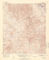
(16)- 1950 Map of Rockinstraw Mtn
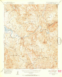 1950 Rockinstraw Mtn1950 Print · USGSGila County's high desert and river canyons are captured here in the mid-century, featuring the dramatic shoreline of the Roosevelt Reservoir. Genealogists and historians can trace old forest outposts like A-Cross Ranger Sta and mining sites near Richmond Basin.2 unique versions available
 - 1950 Map of McFadden Peak
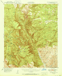 1950 McFadden Peak1950 Print · USGSThe high Sierra Ancha of Gila County comes into focus mid-century, showing a landscape defined by ranching, mining, and forest management. Genealogists and researchers can locate historic family holdings like Circle Ranch and Tanner Ranch, or trace early operations at the Pueblo Mine.2 unique versions available
 - 1950 Map of Winkelman
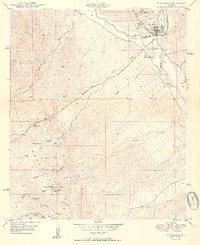 1950 Winkelman1950 Print · USGSThe confluence of the Gila and San Pedro Rivers comes alive in this mid-century survey of Gila and Pinal Counties. Researchers can trace the industrial footprint of Hayden and Winkelman, or locate remote sites like Antelope Mine and Flying UW Ranch.2 unique versions available
 - 1951 Map of Blue House Mtn
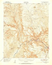 1951 Blue House Mtn1951 Print · USGSGila County canyon country in the early fifties reveals a landscape of industrial mining and ancient archaeology. Trace deep-canyon mineral workings at the Regal Mine and Canadian Mines, or locate historical sites like the Sanrace Cliff Dwellings.2 unique versions available
 - 1951 Map of Winkelman
 1951 Winkelman1951 Print · USGSWinkelman and the lower Gila River valley are documented here at mid-century, capturing the intersection of industrial mining and desert ranching. Researchers can trace historic family operations like the Flying UW Ranch and locate old mining claims such as the Ripsey Mine and Silver Queen Mine.2 unique versions available
 - 1952 Map of Pine, 1956 Print
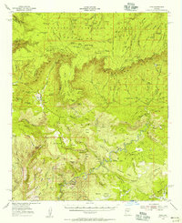 1952 Pine1956 Print · USGSPine and Strawberry sit just below the massive Mogollon Rim in the 1950s, a period when this high-country landscape was defined by remote ranches and forest lookouts. Researchers can trace the High Line Trail and locate family-history sites like Chase Ranch and the Cem at Pine.3 unique versions available
 - 1952 Map of Promontory Butte, 1956 Print
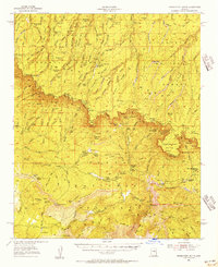 1952 Promontory Butte1956 Print · USGSThe Mogollon Rim country comes to life in the 1950s at the junction of three national forests. Researchers can locate remote cattle operations like Pyle Ranch and Haught Ranch, or trace the path of the Highline Trail below Promontory Butte.4 unique versions available
 - 1954 Map of Holbrook, 1966 Print
 1954 Holbrook1966 Print · USGSNorth-central Arizona is seen here during the mid-fifties, from the high plateau of the Mogollon Rim to the Verde Valley. Researchers can trace the early growth of Holbrook, locate remote camps like Happy Jack, and explore the roads around Montezuma Castle National Monument.3 unique versions available
 - 1954 Map of Mesa, 1968 Print
 1954 Mesa1968 Print · USGSCentral Arizona in the mid-fifties reveals the rapid growth of the Valley of the Sun alongside the deep-rooted mining districts of the eastern mountains. Genealogists and researchers can trace the expansion of Mesa and Chandler or locate legacy operations at Inspiration Mine and the Magma Arizona railroad.4 unique versions available
 - 1956 Map of Tucson, 1967 Print
 1956 Tucson1967 Print · USGSPost-war Southern Arizona comes into focus as the copper and aviation industries expand around Tucson. Trace family roots in South Tucson or locate early mining sites like the San Manuel Mine and Silver Bell Mine near the Santa Cruz River.3 unique versions available
 - 1957 Map of Mesa
 1957 Mesa1957 Print · USGSCentral Arizona's desert valleys and high-mountain mining districts come alive in the mid-fifties. Researchers can trace the early layout of Mesa and Phoenix or locate remote sites like Inspiration Mine and Arizona State College.
 - 1957 Map of Holbrook
 1957 Holbrook1957 Print · USGSNorthern Arizona in the mid-fifties is defined by the high-plateau timberlands and the bustling rail corridor of the Little Colorado River valley. Genealogists and historians can trace the route of U.S. 66 through Holbrook or locate more remote outposts like Zeniff and Aripine.
 - 1958 Map of Mesa
 1958 Mesa1958 Print · USGSMid-century Arizona comes alive in this survey of the valley and high desert, where urban growth begins to transform the landscape. Genealogists and researchers can trace the rail-and-mine economy through Inspiration Mine and old stops like Rittenhouse and Magma.
 - 1958 Map of Holbrook
 1958 Holbrook1958 Print · USGSNortheastern Arizona's high country is captured here during the mid-fifties, showing the growth of mountain towns and timber lands. Researchers can trace the Atchison Topeka & Santa Fe RR through Holbrook or find vanished spots like Zeniff.
 - 1958 Map of Tucson
 1958 Tucson1958 Print · USGSSouthern Arizona in the late fifties reveals a landscape of desert agriculture and rising military aviation. Trace the rail lines of the Southern Pacific or locate the historic San Xavier Del Bac Mission and the Casa Grande Natl Mon.
 - 1959 Map of Tucson
 1959 Tucson1959 Print · USGSSouthern Arizona in the late fifties shows a landscape of military growth and desert industry. Genealogists and historians can trace the footprint of Davis-Monthan Air Force Base and old mining sites like the San Manuel Mine near Mammoth.2 unique versions available
End of results
Showing maps 1-16 of 16
Top cities of Gila County
- Payson historical maps
- Globe historical maps
- San Carlos historical maps
- Star Valley historical maps
- Pine historical maps
- Miami historical maps
See more
Frequently asked questions
- What are the different types of historical maps available for Gila County?
- What is the oldest map of Gila County?
- Where can I purchase historical maps of Gila County for my home or office?
- Where can I download high-res historical maps of Gila County?
- Are there historical topographic maps available for Gila County?
- Is there historical aerial imagery available for Gila County?
- Where are historical maps of Gila County sourced from?