1910s Maps of Gila County, Arizona
Explore 6 historic maps of Gila County from the 1910s. These maps offer a rare glimpse into what life looked like during the 1910s — showing old roads, neighborhoods, homes, and landmarks that have changed or disappeared over time.
Whether you're researching your family's past, planning a metal detecting trip, or studying how Gila County's landscape evolved across the 1910s, these high-resolution maps are a powerful tool for exploring the history of this region.
- Focus on a specific era: All maps on this page are from the 1910s, giving you a focused view of this time period.
- See what’s changed: Compare century-old streets, trails, and buildings to today's modern landscape using overlays and satellite layers.
- Research with precision: Use these maps for genealogy, historical research, land use analysis, or educational projects.
- View, download, or print: Maps are fully viewable online in high resolution, and can be downloaded or printed for your own records.
Start exploring Gila County's history through authentic maps from the 1910s. This is your window into the past.
Gila County, AZ maps
(6)- 1910 Map of Ray
 1910 Ray1910 Print · USGSArizona's copper country and Gila River basin are captured here at a peak of early industrial expansion. Genealogy researchers can locate early homesteads like Uncle Dan's Ranch and Winkelman's Ranch, alongside the massive Ray Mine and the Phoenix and Eastern R. R. corridor.3 unique versions available
 - 1911 Map of Winkelman, 1957 Print
 1911 Winkelman1957 Print · USGSThe Pinal and Pima County line comes alive in the 1910s, showing a landscape of mining camps and early ranching. Genealogists and historians can trace the foundations of Mammoth and find long-lost sites like the Finch School, Campo Bonito, and the MAMMOTH MINE.
 - 1912 Map of Roosevelt
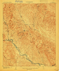
 1912 Roosevelt1912 Print · USGSCentral Arizona is captured here during the transformative years following the completion of the Roosevelt Dam. You can trace early ranching homesteads such as Clines Ranch and Howell's Ranch or locate the site of Schell's Station.4 unique versions available
 - 1913 Map of Winkelman
 1913 Winkelman1913 Print · USGSThe confluence of the Gila and San Pedro rivers in the 1910s reveals a landscape of mining camps and remote ranching outposts. Trace the early industrial footprint of the Mammoth Mine and Oracle or find family landmarks like Finch School and Biddicks Cabin.4 unique versions available
 - 1915 Map of Christmas, 1957 Print
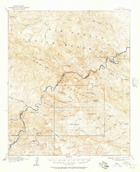 1915 Christmas1957 Print · USGSThe Gila River canyon and Mescal Mountains are shown here during the peak of early Arizona mining and ranching. Genealogists and historians can trace the foundations of the Christmas settlement, the Arizona Eastern rail line, and remote sites like Mings Ranch or the Lower Coal Field Mine.2 unique versions available
 - 1917 Map of Christmas
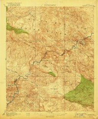 1917 Christmas1917 Print · USGSMining camps and desert ranching take center stage in this Gila County survey conducted just after the turn of the century. Genealogists and historians can trace the early footprint of Christmas and the various mineral works of the region, from the Lee Mine to the Old Mill.3 unique versions available
End of results
Showing maps 1-6 of 6
Top cities of Gila County
- Payson historical maps
- Globe historical maps
- San Carlos historical maps
- Star Valley historical maps
- Pine historical maps
- Miami historical maps
See more
Frequently asked questions
- What are the different types of historical maps available for Gila County?
- What is the oldest map of Gila County?
- Where can I purchase historical maps of Gila County for my home or office?
- Where can I download high-res historical maps of Gila County?
- Are there historical topographic maps available for Gila County?
- Is there historical aerial imagery available for Gila County?
- Where are historical maps of Gila County sourced from?