1980s Maps of Gila County, Arizona
Explore 18 historic maps of Gila County from the 1980s. These maps offer a rare glimpse into what life looked like during the 1980s — showing old roads, neighborhoods, homes, and landmarks that have changed or disappeared over time.
Whether you're researching your family's past, planning a metal detecting trip, or studying how Gila County's landscape evolved across the 1980s, these high-resolution maps are a powerful tool for exploring the history of this region.
- Focus on a specific era: All maps on this page are from the 1980s, giving you a focused view of this time period.
- See what’s changed: Compare century-old streets, trails, and buildings to today's modern landscape using overlays and satellite layers.
- Research with precision: Use these maps for genealogy, historical research, land use analysis, or educational projects.
- View, download, or print: Maps are fully viewable online in high resolution, and can be downloaded or printed for your own records.
Start exploring Gila County's history through authentic maps from the 1980s. This is your window into the past.
Gila County, AZ maps
(18)- 1981 Map of Payson
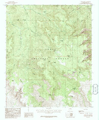
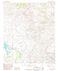
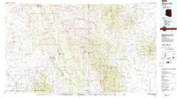
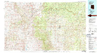 1981 Payson1981 Print · USGSCentral Arizona's mountain country comes into focus in the early eighties, centered on the growing town of Payson. Trace the mining history at Gowan Mine, find old forest outposts like Kohls Ranch, and see the rugged Mogollon Rim terrain.2 unique versions available
 - 1981 Map of Show Low, 1982 Print
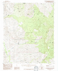
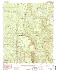
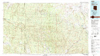 1981 Show Low1982 Print · USGSThe Mogollon Rim highlands in the early eighties were a landscape of forest service outposts and remote reservation settlements. Local historians can trace the foundations of Show Low and Snowflake, or locate family sites near Cibecue and Heber.2 unique versions available
 - 1985 Map of Cane Springs Mountain
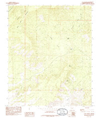 1985 Cane Springs Mountain1985 Print · USGSNorthwest Arizona in the mid-1980s was a landscape of remote mountain peaks and vital desert water sources. Researchers can trace the network of drainage washes and ranching landmarks like Cane Springs, Mud Springs, and the prominent Cane Springs Mountain.
 - 1986 Map of Rock House
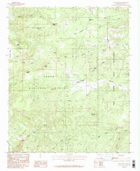 1986 Rock House1986 Print · USGSCentral Arizona in the mid-1980s reveals a landscape where the Tonto National Forest and Fort Apache Indian Reservation converge. Genealogists and historians can locate remote landmarks like Rock House, numerous isolated prospects, and family-named features such as Pendleton Mesa.
 - 1986 Map of Aztec Peak
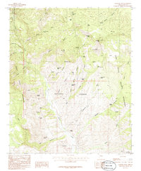
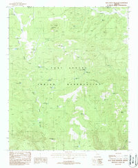
 1986 Aztec Peak1986 Print · USGSThe high ridges of Gila County are captured here in the mid-eighties, centered on the Aztec Peak lookout and the surrounding Sierra Ancha Wilderness. Researchers can trace old mountain trails, remote springs like Cienega Spring, and the location of Asbestos Point.2 unique versions available
 - 1986 Map of Rockinstraw Mountain
 1986 Rockinstraw Mountain1986 Print · USGSGila County's high desert peaks and deep canyons are captured here in the mid-1980s, documenting a landscape of remote wilderness and historical mining. Traces of early exploration can be found near Richmond Basin, where old shafts and prospects neighbor numerous named water sources like Wood Springs.
 - 1986 Map of Dagger Peak
 1986 Dagger Peak1986 Print · USGSThe Gila County backcountry in the mid-eighties shows a rugged landscape where the SALT RIVER and Cherry Creek converge. Researchers can trace remote water sources like Bill Lee Spring and Liquor Spring or locate the boundary of the Fort Apache Indian Reservation.
 - 1986 Map of Globe
 1986 Globe1986 Print · USGSThe copper districts of Gila County and the lands of the San Carlos Apache are detailed here during the mid-eighties. Researchers can trace the industrial footprint of the Miami Mine, the sprawling San Carlos Reservoir, and small riverside settlements like Bylas and Geronimo.2 unique versions available
 - 1986 Map of Meddler Wash
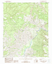
 1986 Meddler Wash1986 Print · USGSGila County in the mid-eighties shows a rugged landscape defined by the Salt River and its transition into Theodore Roosevelt Lake. Researchers can trace remote settlements like A-Cross, explore the ridges of Black Mesa, and locate desert water sources like Tin Shack Spring.
 - 1986 Map of McFadden Peak
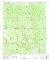
 1986 McFadden Peak1986 Print · USGSThe high country of Gila County is captured in the mid-eighties, showing a landscape defined by cattle ranching and wilderness conservation. Researchers can trace historic pack trails and water sources like Ash Creek Spring, Turkey Spring, and the prominent McFadden Peak.2 unique versions available
 - 1986 Map of Sombrero Peak
 1986 Sombrero Peak1986 Print · USGSGila County's high desert peaks and deep canyons are documented here in the mid-1980s, just as the area was being formally managed for wilderness preservation. Researchers can locate remote landmarks like Pottery Point and Devils Chasm, or trace the complex network of water sources including Bermuda Falls Spring and Yellow Jacket Spring.2 unique versions available
 - 1986 Map of Salt River Peak
 1986 Salt River Peak1986 Print · USGSGila County's high desert reveals its network of springs and canyons in the mid-1980s. Researchers can locate remote water sources and landmarks like High Blevens Spring, Salt River Peak, and the winding Salt River.
 - 1986 Map of Mammoth, 1987 Print
 1986 Mammoth1987 Print · USGSThe copper-rich corridors of Pinal and Graham counties are captured in the mid-1980s as mining towns and mountain wilderness met. Researchers can trace the industrial footprints of the San Manuel Mine and Hayden, alongside landmarks like the Silver Queen Mine and Aravaipa Creek.3 unique versions available
 - 1988 Map of Blue House Mountain
 1988 Blue House Mountain1988 Print · USGSGila and Navajo counties are shown here in the late 1980s, documenting a landscape of high ridges and critical water sources. Researchers can trace land use through features like Brown Cabin Tank, Blue House Spring, and the Rock House Butte landmark.
 - 1988 Map of Double Buttes
 1988 Double Buttes1988 Print · USGSThe Fort Apache Indian Reservation comes into focus during the late eighties, showing a landscape defined by deep canyons and critical water catchments. Researchers can trace the drainage of Canyon Creek or locate vital springs and stock tanks like Wild Nut Spring and Keystone Tank.
 - 1988 Map of Picacho Colorado
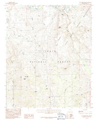
 1988 Picacho Colorado1988 Print · USGSThe Gila County high country in the late eighties reveals a stark landscape where the Fort Apache Indian Reservation meets the Salt River. Researchers can trace remote mining activity through several prospects and find vital water sources like Albert Spring and Cedar Spring.
 - 1988 Map of Mule Hoof Bend
 1988 Mule Hoof Bend1988 Print · USGSGila County’s remote canyon country is captured here in the late 1980s, where three major public and tribal lands meet along the Salt River. Researchers can trace the era’s active mining landscape at the Apache Mine and Regal Mine, or locate local landmarks like the Jimana Inn near Seneca.2 unique versions available
 - 1989 Map of San Carlos Reservoir, 1990 Print
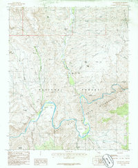
 1989 San Carlos Reservoir1990 Print · USGSGraham County and the San Carlos Indian Reservation appear in the late eighties as the reservoir fills the desert floor. Researchers can trace the Old Indian Treaty Boundary and locate remote water sources like Wire Corral Spring and Squaw Canyon Well.
End of results
Showing maps 1-18 of 18
Top cities of Gila County
- Payson historical maps
- Globe historical maps
- San Carlos historical maps
- Star Valley historical maps
- Pine historical maps
- Miami historical maps
See more
Frequently asked questions
- What are the different types of historical maps available for Gila County?
- What is the oldest map of Gila County?
- Where can I purchase historical maps of Gila County for my home or office?
- Where can I download high-res historical maps of Gila County?
- Are there historical topographic maps available for Gila County?
- Is there historical aerial imagery available for Gila County?
- Where are historical maps of Gila County sourced from?