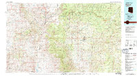
1981 Map of Payson
USGS Topo · Published 1981About this map
The Mogollon Rim dominates this 1981 landscape, a dramatic escarpment that separates the high plateau of the Coconino National Forest from the lower basins to the south. Central to this topography is Payson, situated as a mountain crossroads where State Highway 87 and State Highway 260 meet. This era shows the settlement patterns within the Tonto National Forest, where smaller communities like Pine, Strawberry, and Gisela follow the reliable water sources of the East Verde River and Tonto Creek.
Find a feature on this map
63 named features on this map. Tap any name to fly to it.
Don’t see what you’re looking for? This feature index may not catch every label — zoom into the map to look around manually.
Map Details
Editions of this 1981 Payson Map
2 editions found
Other maps of this area

1886 · Holbrook
USGS Topo · 1:250,000

1887 · Verde
USGS Topo · 1:250,000

1887 · Prescott
USGS Topo · 1:250,000

1892 · Verde
USGS Topo · 1:250,000

1892 · Prescott
USGS Topo · 1:250,000

1893 · Holbrook
USGS Topo · 1:250,000

1903 · Bradshaw Mountains
USGS Topo · 1:125,000

1905 · Jerome
USGS Topo · 1:125,000

1907 · Roosevelt
USGS Topo · 1:125,000

1909 · Four Peaks
USGS Topo · 1:125,000