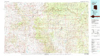
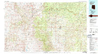
1981 Map of Payson
USGS Topo · Published 1981About this map
The Mogollon Rim dominates the upper reaches of this 1981 survey, where the high country of the Sitgreaves National Forest and Coconino National Forest drops sharply toward the desert transition zone below. Central to this landscape is Payson, the hub for surrounding mountain communities like Strawberry and Pine. The map illustrates a complex drainage system where the East Verde River and Tonto Creek carve through the foothills of the Mazatzal Mountains. Local industry and heritage are represented by the Sunflower Mine and Gowan Mine, while the expansion of remote residential settlements is evident at Tonto Village and Star Valley. The presence of the Mazatzal Wilderness and Pine Mountain Wilderness highlights the preservation of this interior Arizona backcountry during the late twentieth century.
Find a feature on this map
46 named features on this map. Tap any name to fly to it.
Don’t see what you’re looking for? This feature index may not catch every label — zoom into the map to look around manually.
Map Details
Editions of this 1981 Payson Map
2 editions found
Other maps of this area

1886 · Holbrook
USGS Topo · 1:250,000

1887 · Verde
USGS Topo · 1:250,000

1887 · Prescott
USGS Topo · 1:250,000

1892 · Verde
USGS Topo · 1:250,000

1892 · Prescott
USGS Topo · 1:250,000

1893 · Holbrook
USGS Topo · 1:250,000

1903 · Bradshaw Mountains
USGS Topo · 1:125,000

1905 · Jerome
USGS Topo · 1:125,000

1907 · Roosevelt
USGS Topo · 1:125,000

1909 · Four Peaks
USGS Topo · 1:125,000