Loading...
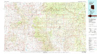
Loading map...1936 Map of Payson
USGS Topo · Published 1965About this map
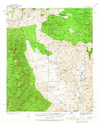
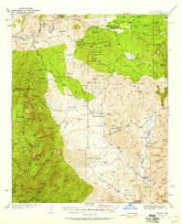
Payson serves as the central hub of this mid-1930s survey, surrounded by an intensive network of mining operations and remote cattle ranches within the Tonto National Forest. The local economy of the era is clearly etched into the landscape through features like Silver King Mine, Wonder Mine, and Vans Mill, while the presence of a Landing Field and the Felton Service Sta north of Gold Creek signals the modernization of transport through the Mazatzal Mountains.
Find a feature on this map
109 named features on this map. Tap any name to fly to it.
Don’t see what you’re looking for? This feature index may not catch every label — zoom into the map to look around manually.
Map Details
Date Portrayed1936
Date Published1965
PublisherU.S. Geological Survey
Map TypeTopographic
Scale1:62,500
Physical Dimensions16.9 x 20.8 inches
Editions of this 1936 Payson Map
3 editions found
Historical Maps of Payson Through Time
Featured Locations
Source Details
SourceU.S. Geological Survey
CopyrightPublic Domain