
1905 Map of Jerome
USGS Topo · Published 1905About this map
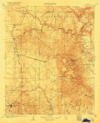
The mining town of Jerome sits perched on the steep eastern slopes of the Black Hills, overlooking the Verde River valley during a period of intense industrial growth. This 1905 survey details the specialized rail infrastructure required to move ore through the high desert, specifically the United Verde and Pacific RR which snakes eastward from Jerome Junc to reach the mines. To the south, the established regional hub of Prescott is shown alongside the military grounds of Fort Whipple, connected to the wider territory by the Santa Fe Prescott and Phoenix RR.
Find a feature on this map
74 named features on this map. Tap any name to fly to it.
Don’t see what you’re looking for? This feature index may not catch every label — zoom into the map to look around manually.
Map Details
Editions of this 1905 Jerome Map
2 editions found
Historical Maps of Prescott Through Time
1 maps found