1910s Maps of Lakes at Rancho El Dorado, Maricopa
Explore 2 historic maps of Lakes at Rancho El Dorado from the 1910s. These maps offer a rare glimpse into what life looked like during the 1910s — showing old roads, neighborhoods, homes, and landmarks that have changed or disappeared over time.
Whether you're researching your family's past, planning a metal detecting trip, or studying how Lakes at Rancho El Dorado's landscape evolved across the 1910s, these high-resolution maps are a powerful tool for exploring the history of this region.
- Focus on a specific era: All maps on this page are from the 1910s, giving you a focused view of this time period.
- See what’s changed: Compare century-old streets, trails, and buildings to today's modern landscape using overlays and satellite layers.
- Research with precision: Use these maps for genealogy, historical research, land use analysis, or educational projects.
- View, download, or print: Maps are fully viewable online in high resolution, and can be downloaded or printed for your own records.
Start exploring Lakes at Rancho El Dorado's history through authentic maps from the 1910s. This is your window into the past.
Lakes at Rancho El Dorado, Maricopa maps
(2)- 1913 Map of Maricopa, 1958 Print
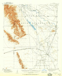 1913 Maricopa1958 Print · USGSArizona's desert interior comes to life in this early twentieth-century survey of the Gila River Valley. Researchers can trace the shifting rail lines through Maricopa and locate the historic site of Maricopa Wells (Abandoned) or Pima Village.
 - 1915 Map of Maricopa
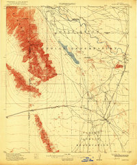 1915 Maricopa1915 Print · USGSThe Gila River Valley and its early twentieth-century reservations are captured here as the railroad began to redefine Arizona's desert hubs. Genealogists and historians can trace old stops like Maricopa Wells (Abandoned), the rail junction at Maricopa, and the peaks of the Sierra Estrella.2 unique versions available
End of results
Showing maps 1-2 of 2
Frequently asked questions
- What are the different types of historical maps available for Lakes at Rancho El Dorado?
- What is the oldest map of Lakes at Rancho El Dorado?
- Where can I purchase historical maps of Lakes at Rancho El Dorado for my home or office?
- Where can I download high-res historical maps of Lakes at Rancho El Dorado?
- Are there historical topographic maps available for Lakes at Rancho El Dorado?
- Is there historical aerial imagery available for Lakes at Rancho El Dorado?
- Where are historical maps of Lakes at Rancho El Dorado sourced from?