1990s Maps of Picacho, Arizona
Explore 2 historic maps of Picacho from the 1990s. These maps offer a rare glimpse into what life looked like during the 1990s — showing old roads, neighborhoods, homes, and landmarks that have changed or disappeared over time.
Whether you're researching your family's past, planning a metal detecting trip, or studying how Picacho's landscape evolved across the 1990s, these high-resolution maps are a powerful tool for exploring the history of this region.
- Focus on a specific era: All maps on this page are from the 1990s, giving you a focused view of this time period.
- See what’s changed: Compare century-old streets, trails, and buildings to today's modern landscape using overlays and satellite layers.
- Research with precision: Use these maps for genealogy, historical research, land use analysis, or educational projects.
- View, download, or print: Maps are fully viewable online in high resolution, and can be downloaded or printed for your own records.
Start exploring Picacho's history through authentic maps from the 1990s. This is your window into the past.
Picacho, AZ maps
(2)- 1994 Map of Casa Grande
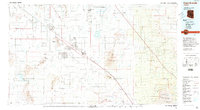 1994 Casa Grande1994 Print · USGSPinal County in the early nineties shows a desert landscape shaped by massive irrigation projects and ancient heritage. Trace the path of the Southern Pacific past Casa Grande National Monument Ruins and the Silver Reef Mine.3 unique versions available
 - 1996 Map of Newman Peak, 2003 Print
 1996 Newman Peak2003 Print · USGSPinal County's desert corridor is captured here in the late nineties, where massive water works and iconic mountain peaks meet the highway. Trace the development of infrastructure like the Central Arizona Project Aqueduct or locate the Picacho Stagefield Control Tower and Picacho Peak State Park.
End of results
Showing maps 1-2 of 2
Top cities near Picacho
- Casa Grande historical maps
- Marana historical maps
- Eloy historical maps
- Coolidge historical maps
- Arizona City historical maps
- Red Rock historical maps
Frequently asked questions
- What are the different types of historical maps available for Picacho?
- What is the oldest map of Picacho?
- Where can I purchase historical maps of Picacho for my home or office?
- Where can I download high-res historical maps of Picacho?
- Are there historical topographic maps available for Picacho?
- Is there historical aerial imagery available for Picacho?
- Where are historical maps of Picacho sourced from?