1940s Maps of Sif Oidak District, Arizona
Explore 7 historic maps of Sif Oidak District from the 1940s. These maps offer a rare glimpse into what life looked like during the 1940s — showing old roads, neighborhoods, homes, and landmarks that have changed or disappeared over time.
Whether you're researching your family's past, planning a metal detecting trip, or studying how Sif Oidak District's landscape evolved across the 1940s, these high-resolution maps are a powerful tool for exploring the history of this region.
- Focus on a specific era: All maps on this page are from the 1940s, giving you a focused view of this time period.
- See what’s changed: Compare century-old streets, trails, and buildings to today's modern landscape using overlays and satellite layers.
- Research with precision: Use these maps for genealogy, historical research, land use analysis, or educational projects.
- View, download, or print: Maps are fully viewable online in high resolution, and can be downloaded or printed for your own records.
Start exploring Sif Oidak District's history through authentic maps from the 1940s. This is your window into the past.
Sif Oidak District, AZ maps
(7)- 1941 Map of Vekol Mountains
 1941 Vekol Mountains1941 Print · USGSMining activity and tribal settlements characterize this desert region in the late 1930s. Genealogists and historians can trace indigenous communities at Sif Vaya and Kohatk alongside early mineral prospects like the Vekol Mine and Reward Mine.
 - 1942 Map of Silver Reef Mountains
 1942 Silver Reef Mountains1942 Print · USGSPinal County's desert mining and indigenous heritage are recorded here in the early 1940s, just as these remote districts were being systematically surveyed. Genealogists and historians can trace the locations of traditional settlements like Vaiva Vo and Kohatk alongside numerous mining claims including the Silver Reef Mine and Jackrabbit Mine.2 unique versions available
 - 1942 Map of Vekol Mountains
 1942 Vekol Mountains1942 Print · USGSThe high desert of southern Arizona comes into focus during the late 1930s as a hub for mineral exploration and tribal settlement. Miners and genealogists can trace the locations of the Vekol Mine, Copperosity Mine, and the settlement of Sif Vaya.
 - 1946 Map of Antelope Peak, 1955 Print
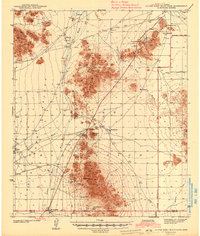
 1946 Antelope Peak1955 Print · USGSThe high desert of Pinal County in the late 1940s is captured here, showing the intersection of tribal lands and the open basin. Researchers can trace early routes like Route 84 past prominent landmarks like Antelope Peak, Table Top, and the watering holes of Hidden Valley.3 unique versions available
 - 1947 Map of Eloy, 1959 Print
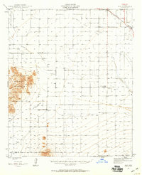 1947 Eloy1959 Print · USGSThe Pinal County desert just after the war shows a landscape of rail transit and early agricultural irrigation. Trace the development of Eloy and Picacho along the Southern Pacific Railroad or locate the Sawtooth Sch and Friendly Corners.2 unique versions available
 - 1948 Map of Antelope Peak
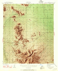
 1948 Antelope Peak1948 Print · USGSThe high desert south of Phoenix comes alive in the late 1940s, showing the dramatic rise of Antelope Peak and Table Top above the valley floor. Researchers can trace the early borders of the Maricopa Indian Reservation and locate isolated desert Well sites and the winding Vekol Wash.2 unique versions available
 - 1948 Map of Eloy
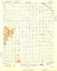 1948 Eloy1948 Print · USGSMid-century Pinal County comes into focus as a developing agricultural and rail hub centered on the Southern Pacific line. You can trace early irrigation works and rural landmarks like the Sawtooth Sch, the Friendly Corners settlement, and the U S Dept of Agric Farm Labor Camp.
End of results
Showing maps 1-7 of 7
Top cities near Sif Oidak District
Top neighborhoods of Sif Oidak District
- Kohatk historical maps
- Vaiva Vo historical maps
- Chiapuk historical maps
- Shopishk historical maps
- North Komelik historical maps
- Tat Momoli historical maps
See more
Frequently asked questions
- What are the different types of historical maps available for Sif Oidak District?
- What is the oldest map of Sif Oidak District?
- Where can I purchase historical maps of Sif Oidak District for my home or office?
- Where can I download high-res historical maps of Sif Oidak District?
- Are there historical topographic maps available for Sif Oidak District?
- Is there historical aerial imagery available for Sif Oidak District?
- Where are historical maps of Sif Oidak District sourced from?