1940s Maps of Shopishk, Sif Oidak District
Explore 1 historic maps of Shopishk from the 1940s. These maps offer a rare glimpse into what life looked like during the 1940s — showing old roads, neighborhoods, homes, and landmarks that have changed or disappeared over time.
Whether you're researching your family's past, planning a metal detecting trip, or studying how Shopishk's landscape evolved across the 1940s, these high-resolution maps are a powerful tool for exploring the history of this region.
- Focus on a specific era: All maps on this page are from the 1940s, giving you a focused view of this time period.
- See what’s changed: Compare century-old streets, trails, and buildings to today's modern landscape using overlays and satellite layers.
- Research with precision: Use these maps for genealogy, historical research, land use analysis, or educational projects.
- View, download, or print: Maps are fully viewable online in high resolution, and can be downloaded or printed for your own records.
Start exploring Shopishk's history through authentic maps from the 1940s. This is your window into the past.
Shopishk, Sif Oidak District maps
(1)- 1942 Map of Silver Reef Mountains
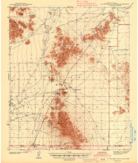 1942 Silver Reef Mountains1942 Print · USGSPinal County's desert mining and indigenous heritage are recorded here in the early 1940s, just as these remote districts were being systematically surveyed. Genealogists and historians can trace the locations of traditional settlements like Vaiva Vo and Kohatk alongside numerous mining claims including the Silver Reef Mine and Jackrabbit Mine.2 unique versions available
End of results
Showing maps 1-1 of 1
Top cities near Shopishk
- Casa Grande historical maps
- Eloy historical maps
- Coolidge historical maps
- Arizona City historical maps
- Chuichu historical maps
Frequently asked questions
- What are the different types of historical maps available for Shopishk?
- What is the oldest map of Shopishk?
- Where can I purchase historical maps of Shopishk for my home or office?
- Where can I download high-res historical maps of Shopishk?
- Are there historical topographic maps available for Shopishk?
- Is there historical aerial imagery available for Shopishk?
- Where are historical maps of Shopishk sourced from?