1940s Maps of Bagdad, Arizona
Explore 3 historic maps of Bagdad from the 1940s. These maps offer a rare glimpse into what life looked like during the 1940s — showing old roads, neighborhoods, homes, and landmarks that have changed or disappeared over time.
Whether you're researching your family's past, planning a metal detecting trip, or studying how Bagdad's landscape evolved across the 1940s, these high-resolution maps are a powerful tool for exploring the history of this region.
- Focus on a specific era: All maps on this page are from the 1940s, giving you a focused view of this time period.
- See what’s changed: Compare century-old streets, trails, and buildings to today's modern landscape using overlays and satellite layers.
- Research with precision: Use these maps for genealogy, historical research, land use analysis, or educational projects.
- View, download, or print: Maps are fully viewable online in high resolution, and can be downloaded or printed for your own records.
Start exploring Bagdad's history through authentic maps from the 1940s. This is your window into the past.
Bagdad, AZ maps
(3)- 1942 Map of Signal
 1942 Signal1942 Print · USGSNorthwestern Arizona was a rugged network of mining camps and river crossings during the early years of the war. Researchers can trace the isolated roads connecting Signal, the mines at Bagdad, and the remote desert outposts of Swansea and Alamo.
 - 1945 Map of Bagdad, 1964 Print
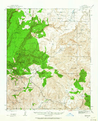 1945 Bagdad1964 Print · USGSThe copper district of Yavapai County is captured here in the mid-1940s, showing the early industrial footprint of Bagdad. Researchers can trace the era's mining landscape through the Black Pearl Mine, Old Dick Mine, and the remote Bozarth Ranch.3 unique versions available
 - 1948 Map of Bagdad
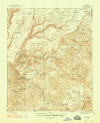 1948 Bagdad1948 Print · USGSArizona's copper and gold mining landscape is captured here in the late 1940s, centered on the growing town of Bagdad. Genealogists and industrial historians can trace early claims and cattle operations through labels like Hillside Mine, Bozarth Ranch, and the Cowboy Mine.2 unique versions available
End of results
Showing maps 1-3 of 3
Frequently asked questions
- What are the different types of historical maps available for Bagdad?
- What is the oldest map of Bagdad?
- Where can I purchase historical maps of Bagdad for my home or office?
- Where can I download high-res historical maps of Bagdad?
- Are there historical topographic maps available for Bagdad?
- Is there historical aerial imagery available for Bagdad?
- Where are historical maps of Bagdad sourced from?