1960s Maps of Dugas, Arizona
Explore 2 historic maps of Dugas from the 1960s. These maps offer a rare glimpse into what life looked like during the 1960s — showing old roads, neighborhoods, homes, and landmarks that have changed or disappeared over time.
Whether you're researching your family's past, planning a metal detecting trip, or studying how Dugas's landscape evolved across the 1960s, these high-resolution maps are a powerful tool for exploring the history of this region.
- Focus on a specific era: All maps on this page are from the 1960s, giving you a focused view of this time period.
- See what’s changed: Compare century-old streets, trails, and buildings to today's modern landscape using overlays and satellite layers.
- Research with precision: Use these maps for genealogy, historical research, land use analysis, or educational projects.
- View, download, or print: Maps are fully viewable online in high resolution, and can be downloaded or printed for your own records.
Start exploring Dugas's history through authentic maps from the 1960s. This is your window into the past.
Dugas, AZ maps
(2)- 1960 Map of Holbrook
 1960 Holbrook1960 Print · USGSNorthern Arizona is captured here just as modern highways began to reshape the cattle and timber country of the Colorado Plateau. Genealogists and historians can trace the early footprints of Snowflake, Sedona, and Payson, alongside the Atchison Topeka & Santa Fe RR rail line.
 - 1967 Map of Dugas, 1968 Print
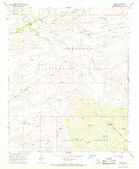 1967 Dugas1968 Print · USGSRanching and forest service outposts define this Yavapai County landscape during the late sixties. Genealogists and historians can trace family-named landmarks like T Anchor Ranch and Indian Creek Ranch, or locate the Sycamore Ranger Station near Dugas.3 unique versions available
End of results
Showing maps 1-2 of 2
Top cities near Dugas
- Prescott Valley historical maps
- Camp Verde historical maps
- Dewey-Humboldt historical maps
- Cordes Lakes historical maps
- Spring Valley historical maps
Frequently asked questions
- What are the different types of historical maps available for Dugas?
- What is the oldest map of Dugas?
- Where can I purchase historical maps of Dugas for my home or office?
- Where can I download high-res historical maps of Dugas?
- Are there historical topographic maps available for Dugas?
- Is there historical aerial imagery available for Dugas?
- Where are historical maps of Dugas sourced from?