1940s Maps of McNary Place, Arizona
Explore 3 historic maps of McNary Place from the 1940s. These maps offer a rare glimpse into what life looked like during the 1940s — showing old roads, neighborhoods, homes, and landmarks that have changed or disappeared over time.
Whether you're researching your family's past, planning a metal detecting trip, or studying how McNary Place's landscape evolved across the 1940s, these high-resolution maps are a powerful tool for exploring the history of this region.
- Focus on a specific era: All maps on this page are from the 1940s, giving you a focused view of this time period.
- See what’s changed: Compare century-old streets, trails, and buildings to today's modern landscape using overlays and satellite layers.
- Research with precision: Use these maps for genealogy, historical research, land use analysis, or educational projects.
- View, download, or print: Maps are fully viewable online in high resolution, and can be downloaded or printed for your own records.
Start exploring McNary Place's history through authentic maps from the 1940s. This is your window into the past.
McNary Place, AZ maps
(3)- 1947 Map of Mt. Union, 1958 Print
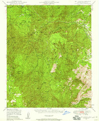 1947 Mt. Union1958 Print · USGSYavapai County's high country is captured here in the late 1940s, showing a landscape of mining camps and early summer retreats. Researchers can trace family homesteads at the McNary Place or locate remote outposts like Goodwin PO and the Butternut Mine.3 unique versions available
 - 1948 Map of Mt. Union
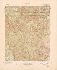 1948 Mt. Union1948 Print · USGSThe Bradshaw Mountains in the late 1940s reveal a landscape of deep-set mining claims and early forest service outposts. Genealogists and historians can locate family sites and remote landmarks like Palace Station, the Jersey Lily Mine, and the Goodwin PO.
 - 1949 Map of Mt. Union
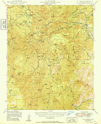 1949 Mt. Union1949 Print · USGSThe Bradshaw Mountains in the late 1940s reveal a landscape of deep-seated mining operations and high-country forest outposts. Genealogists and historians can trace family-named sites like the Dandrea Ranch and McNary Place, or locate the Cem near Palace Station.2 unique versions available
End of results
Showing maps 1-3 of 3
Top cities near McNary Place
Frequently asked questions
- What are the different types of historical maps available for McNary Place?
- What is the oldest map of McNary Place?
- Where can I purchase historical maps of McNary Place for my home or office?
- Where can I download high-res historical maps of McNary Place?
- Are there historical topographic maps available for McNary Place?
- Is there historical aerial imagery available for McNary Place?
- Where are historical maps of McNary Place sourced from?