1940s Maps of Paxton Place, Arizona
Explore 2 historic maps of Paxton Place from the 1940s. These maps offer a rare glimpse into what life looked like during the 1940s — showing old roads, neighborhoods, homes, and landmarks that have changed or disappeared over time.
Whether you're researching your family's past, planning a metal detecting trip, or studying how Paxton Place's landscape evolved across the 1940s, these high-resolution maps are a powerful tool for exploring the history of this region.
- Focus on a specific era: All maps on this page are from the 1940s, giving you a focused view of this time period.
- See what’s changed: Compare century-old streets, trails, and buildings to today's modern landscape using overlays and satellite layers.
- Research with precision: Use these maps for genealogy, historical research, land use analysis, or educational projects.
- View, download, or print: Maps are fully viewable online in high resolution, and can be downloaded or printed for your own records.
Start exploring Paxton Place's history through authentic maps from the 1940s. This is your window into the past.
Paxton Place, AZ maps
(2)- 1947 Map of Crown King, 1955 Print
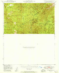 1947 Crown King1955 Print · USGSThe Bradshaw Mountains mining camps are shown at a post-war turning point when old silver and gold workings shared the hills with new forest recreation. Genealogists and metal detectorists can trace historic sites like Fort Misery, the Algonquin Mine, and Paxton Place.
 - 1948 Map of Crown King
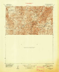 1948 Crown King1948 Print · USGSThe Bradshaw Mountains mining district is captured here shortly after the war, showing the dense network of claims around Crown King. Researchers can locate historic sites like Fort Misery, the Oro Belle Mine, and the route of the Senator Hwy.2 unique versions available
End of results
Showing maps 1-2 of 2
Top cities near Paxton Place
Frequently asked questions
- What are the different types of historical maps available for Paxton Place?
- What is the oldest map of Paxton Place?
- Where can I purchase historical maps of Paxton Place for my home or office?
- Where can I download high-res historical maps of Paxton Place?
- Are there historical topographic maps available for Paxton Place?
- Is there historical aerial imagery available for Paxton Place?
- Where are historical maps of Paxton Place sourced from?