1920s Maps of Arroyo del Fortuna, Yuma County
Explore 2 historic maps of Arroyo del Fortuna from the 1920s. These maps offer a rare glimpse into what life looked like during the 1920s — showing old roads, neighborhoods, homes, and landmarks that have changed or disappeared over time.
Whether you're researching your family's past, planning a metal detecting trip, or studying how Arroyo del Fortuna's landscape evolved across the 1920s, these high-resolution maps are a powerful tool for exploring the history of this region.
- Focus on a specific era: All maps on this page are from the 1920s, giving you a focused view of this time period.
- See what’s changed: Compare century-old streets, trails, and buildings to today's modern landscape using overlays and satellite layers.
- Research with precision: Use these maps for genealogy, historical research, land use analysis, or educational projects.
- View, download, or print: Maps are fully viewable online in high resolution, and can be downloaded or printed for your own records.
Start exploring Arroyo del Fortuna's history through authentic maps from the 1920s. This is your window into the past.
Arroyo del Fortuna, Yuma County maps
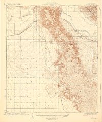
(2)- 1926 Map of Fortuna, 1956 Print
 1926 Fortuna1956 Print · USGSArizona's desert mining and rail corridors are captured here during the mid-1920s as modern utilities began to cross the landscape. Genealogists and historians can trace the Southern Pacific line through Blaisdell or locate the remote Fortuna Mine.
 - 1929 Map of Fortuna
 1929 Fortuna1929 Print · USGSLower Arizona in the late twenties shows a landscape defined by the Gila River and the mining industry. Researchers can trace the Southern Pacific rail line through desert settlements like Blaisdell and Ligurta or locate the Fortuna Mine.4 unique versions available
End of results
Showing maps 1-2 of 2
Frequently asked questions
- What are the different types of historical maps available for Arroyo del Fortuna?
- What is the oldest map of Arroyo del Fortuna?
- Where can I purchase historical maps of Arroyo del Fortuna for my home or office?
- Where can I download high-res historical maps of Arroyo del Fortuna?
- Are there historical topographic maps available for Arroyo del Fortuna?
- Is there historical aerial imagery available for Arroyo del Fortuna?
- Where are historical maps of Arroyo del Fortuna sourced from?