1990s Maps of Crane Annex, Yuma County
Explore 2 historic maps of Crane Annex from the 1990s. These maps offer a rare glimpse into what life looked like during the 1990s — showing old roads, neighborhoods, homes, and landmarks that have changed or disappeared over time.
Whether you're researching your family's past, planning a metal detecting trip, or studying how Crane Annex's landscape evolved across the 1990s, these high-resolution maps are a powerful tool for exploring the history of this region.
- Focus on a specific era: All maps on this page are from the 1990s, giving you a focused view of this time period.
- See what’s changed: Compare century-old streets, trails, and buildings to today's modern landscape using overlays and satellite layers.
- Research with precision: Use these maps for genealogy, historical research, land use analysis, or educational projects.
- View, download, or print: Maps are fully viewable online in high resolution, and can be downloaded or printed for your own records.
Start exploring Crane Annex's history through authentic maps from the 1990s. This is your window into the past.
Crane Annex, Yuma County maps
(2)- 1993 Map of Yuma
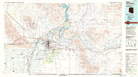 1993 Yuma1993 Print · USGSYuma and the lower Colorado River valley are documented here in the early nineties, showing a landscape defined by massive desert irrigation and military ranges. Trace the rail-and-water economy through the Southern Pacific line and sites like Imperial Dam or the Fortuna Mine.2 unique versions available
 - 1997 Map of Yuma West, 2003 Print
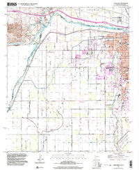 1997 Yuma West2003 Print · USGSThe Colorado River borderlands in the late twentieth century reveal a sophisticated landscape of desert irrigation and military presence. Researchers can trace the water works from Pilot Knob Hydro-electric Plant to the Hanlon Cem and the U S Marine Corps Air Station.
End of results
Showing maps 1-2 of 2
Frequently asked questions
- What are the different types of historical maps available for Crane Annex?
- What is the oldest map of Crane Annex?
- Where can I purchase historical maps of Crane Annex for my home or office?
- Where can I download high-res historical maps of Crane Annex?
- Are there historical topographic maps available for Crane Annex?
- Is there historical aerial imagery available for Crane Annex?
- Where are historical maps of Crane Annex sourced from?