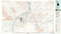
1993 Map of Yuma
USGS Topo · Published 1993About this map
Yuma serves as the focal point of this regional study, situated at the critical confluence of the Colorado River and the Gila River. By the early 1990s, this landscape was defined by massive water management projects and heavy military presence. The Imperial Dam and Laguna Dam regulate the flow that feeds the Wellton-Mohawk Canal, transforming the arid Yuma Desert into productive agricultural land. To the north and east, the map details the expansive Yuma Proving Ground and Barry M Goldwater Air Force Range, which dominate the rugged Chocolate Mountains and Gila Mountains. Historical mining sites such as the American Girl Mine and Fortuna Mine are visible in the surrounding ranges, while the Southern Pacific railroad follows the historic transportation corridor through Wellton and Blaisdell. The map also captures the international boundary with Mexico at San Luis, illustrating the complex border infrastructure of the late twentieth century.
Find a feature on this map
64 named features on this map. Tap any name to fly to it.
Don’t see what you’re looking for? This feature index may not catch every label — zoom into the map to look around manually.
Map Details
Editions of this 1993 Yuma Map
2 editions found
Other maps of this area

1903 · Yuma
USGS Topo · 1:125,000

1905 · Yuma
USGS Topo · 1:125,000

1907 · Holtville
USGS Topo · 1:125,000

1926 · Fortuna
USGS Topo · 1:62,500

1926 · Wellton
USGS Topo · 1:62,500

1926 · Mohawk
USGS Topo · 1:62,500

1928 · Mohawk
USGS Topo · 1:62,500

1928 · Norton
USGS Topo · 1:62,500

1929 · Fortuna
USGS Topo · 1:62,500

1929 · Laguna
USGS Topo · 1:62,500