
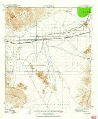
1926 Map of Wellton
USGS Topo · Published 1958About this map
The Southern Pacific railroad corridor serves as the primary artery for settlement through this desert landscape, connecting the railroad towns of Wellton, Adonde, and Tacna. Situated in the Gila Valley, these communities developed around the critical infrastructure of the rail line and the Gila River. The map highlights the early 20th-century reliance on irrigation and basic utilities, noted by features like the Antelope Canal and the functional Gas and Water Road.
Find a feature on this map
21 named features on this map. Tap any name to fly to it.
Don’t see what you’re looking for? This feature index may not catch every label — zoom into the map to look around manually.
Map Details
Editions of this 1926 Wellton Map
2 editions found
Other maps of this area

1926 · Fortuna
USGS Topo · 1:62,500

1926 · Mohawk
USGS Topo · 1:62,500

1928 · Mohawk
USGS Topo · 1:62,500

1928 · Norton
USGS Topo · 1:62,500

1929 · Fortuna
USGS Topo · 1:62,500

1929 · Laguna
USGS Topo · 1:62,500

1929 · Wellton
USGS Topo · 1:62,500

1929 · Norton
USGS Topo · 1:62,500

1942 · Yuma
USGS Topo · 1:250,000

1943 · Laguna
USGS Topo · 1:62,500