1920s Maps of Grande Vista, Arizona
Explore 2 historic maps of Grande Vista from the 1920s. These maps offer a rare glimpse into what life looked like during the 1920s — showing old roads, neighborhoods, homes, and landmarks that have changed or disappeared over time.
Whether you're researching your family's past, planning a metal detecting trip, or studying how Grande Vista's landscape evolved across the 1920s, these high-resolution maps are a powerful tool for exploring the history of this region.
- Focus on a specific era: All maps on this page are from the 1920s, giving you a focused view of this time period.
- See what’s changed: Compare century-old streets, trails, and buildings to today's modern landscape using overlays and satellite layers.
- Research with precision: Use these maps for genealogy, historical research, land use analysis, or educational projects.
- View, download, or print: Maps are fully viewable online in high resolution, and can be downloaded or printed for your own records.
Start exploring Grande Vista's history through authentic maps from the 1920s. This is your window into the past.
Grande Vista, AZ maps
(2)- 1926 Map of Wellton, 1958 Print
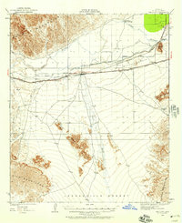 1926 Wellton1958 Print · USGSYuma County during the mid-1920s reveals a desert landscape defined by the arrival of the railroad and the management of the Gila River. Researchers can trace the early footprints of settlements like Wellton and Adonde or locate landmarks such as Radium Hot Springs and Antelope Hill.2 unique versions available
 - 1929 Map of Wellton
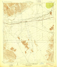 1929 Wellton1929 Print · USGSIn the late 1920s, this desert landscape centered on the Wellton rail corridor and the life-giving Gila River. Genealogists and historians can trace the railway settlements of Adonde and Tacna or locate the site of Radium Hot Springs.3 unique versions available
End of results
Showing maps 1-2 of 2
Top cities near Grande Vista
Frequently asked questions
- What are the different types of historical maps available for Grande Vista?
- What is the oldest map of Grande Vista?
- Where can I purchase historical maps of Grande Vista for my home or office?
- Where can I download high-res historical maps of Grande Vista?
- Are there historical topographic maps available for Grande Vista?
- Is there historical aerial imagery available for Grande Vista?
- Where are historical maps of Grande Vista sourced from?