1920s Maps of Tacna Citrus Estates, Arizona
Explore 2 historic maps of Tacna Citrus Estates from the 1920s. These maps offer a rare glimpse into what life looked like during the 1920s — showing old roads, neighborhoods, homes, and landmarks that have changed or disappeared over time.
Whether you're researching your family's past, planning a metal detecting trip, or studying how Tacna Citrus Estates's landscape evolved across the 1920s, these high-resolution maps are a powerful tool for exploring the history of this region.
- Focus on a specific era: All maps on this page are from the 1920s, giving you a focused view of this time period.
- See what’s changed: Compare century-old streets, trails, and buildings to today's modern landscape using overlays and satellite layers.
- Research with precision: Use these maps for genealogy, historical research, land use analysis, or educational projects.
- View, download, or print: Maps are fully viewable online in high resolution, and can be downloaded or printed for your own records.
Start exploring Tacna Citrus Estates's history through authentic maps from the 1920s. This is your window into the past.
Tacna Citrus Estates, AZ maps
(2)- 1926 Map of Mohawk, 1960 Print
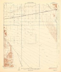
 1926 Mohawk1960 Print · USGSSouthern Arizona rail and river life converge in the mid-twenties as the iron horse crosses the desert floor. Trace the early layout of Mohawk, follow the Southern Pacific tracks to Colfred, or locate the Arizona Consolidated Mining Co works.
 - 1928 Map of Mohawk
 1928 Mohawk1928 Print · USGSIn the late 1920s, the Gila River valley served as a critical corridor for the Southern Pacific railroad and early desert industry. Genealogists and historians can trace small railway stops like Colfred and Gael or locate the remote Arizona Consolidated Mining Co.3 unique versions available
End of results
Showing maps 1-2 of 2
Top cities near Tacna Citrus Estates
Frequently asked questions
- What are the different types of historical maps available for Tacna Citrus Estates?
- What is the oldest map of Tacna Citrus Estates?
- Where can I purchase historical maps of Tacna Citrus Estates for my home or office?
- Where can I download high-res historical maps of Tacna Citrus Estates?
- Are there historical topographic maps available for Tacna Citrus Estates?
- Is there historical aerial imagery available for Tacna Citrus Estates?
- Where are historical maps of Tacna Citrus Estates sourced from?