1960s Maps of Riley, Arkansas
Explore 2 historic maps of Riley from the 1960s. These maps offer a rare glimpse into what life looked like during the 1960s — showing old roads, neighborhoods, homes, and landmarks that have changed or disappeared over time.
Whether you're researching your family's past, planning a metal detecting trip, or studying how Riley's landscape evolved across the 1960s, these high-resolution maps are a powerful tool for exploring the history of this region.
- Focus on a specific era: All maps on this page are from the 1960s, giving you a focused view of this time period.
- See what’s changed: Compare century-old streets, trails, and buildings to today's modern landscape using overlays and satellite layers.
- Research with precision: Use these maps for genealogy, historical research, land use analysis, or educational projects.
- View, download, or print: Maps are fully viewable online in high resolution, and can be downloaded or printed for your own records.
Start exploring Riley's history through authentic maps from the 1960s. This is your window into the past.
Riley, AR maps
(2)- 1960 Map of Mist, 1961 Print
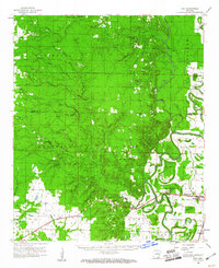 1960 Mist1961 Print · USGSSoutheast Arkansas in the early sixties was a landscape of winding bayous and rail-dependent towns like Montrose and Snyder. Genealogists can locate family-named sites such as Townsend Cem and Judking Cem along the bends of Bayou Bartholomew.2 unique versions available
 - 1960 Map of Mist, 1961 Print
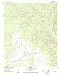 1960 Mist1961 Print · USGSAshley County in the early sixties reveals a landscape shaped by the Missouri Pacific railroad and the vast Banner Prairie. Researchers can trace local genealogy through sites like Central Cem and Mt Olive Ch, or locate the quiet crossroads of Mist and Berea.2 unique versions available
End of results
Showing maps 1-2 of 2
Top cities near Riley
- Monticello historical maps
- Crossett historical maps
- Hamburg historical maps
- North Crossett historical maps
- Portland historical maps
- Montrose historical maps
See more
Frequently asked questions
- What are the different types of historical maps available for Riley?
- What is the oldest map of Riley?
- Where can I purchase historical maps of Riley for my home or office?
- Where can I download high-res historical maps of Riley?
- Are there historical topographic maps available for Riley?
- Is there historical aerial imagery available for Riley?
- Where are historical maps of Riley sourced from?