1930s Maps of Vick, Arkansas
Explore 3 historic maps of Vick from the 1930s. These maps offer a rare glimpse into what life looked like during the 1930s — showing old roads, neighborhoods, homes, and landmarks that have changed or disappeared over time.
Whether you're researching your family's past, planning a metal detecting trip, or studying how Vick's landscape evolved across the 1930s, these high-resolution maps are a powerful tool for exploring the history of this region.
- Focus on a specific era: All maps on this page are from the 1930s, giving you a focused view of this time period.
- See what’s changed: Compare century-old streets, trails, and buildings to today's modern landscape using overlays and satellite layers.
- Research with precision: Use these maps for genealogy, historical research, land use analysis, or educational projects.
- View, download, or print: Maps are fully viewable online in high resolution, and can be downloaded or printed for your own records.
Start exploring Vick's history through authentic maps from the 1930s. This is your window into the past.
Vick, AR maps
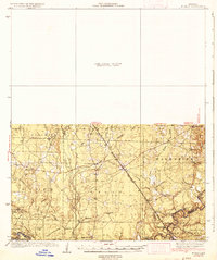
(3)- 1934 Map of Ingalls
 1934 Ingalls1934 Print · USGSBradley County during the mid-1930s shows a landscape of river-bottom camps and rural parish life. Researchers can trace family roots through numerous local landmarks, from Johnsville and Bogalusa Camp to country schools like Eagle Lake Sch and Broad Sch.
 - 1937 Map of Ingalls
 1937 Ingalls1937 Print · USGSSouth Arkansas timber and river country are mapped here in the mid-1930s as rural life centered on the Ouachita River. Researchers can locate vanished landmarks like Pine Island Landing, Thomas Sch, and the riverside Bogalusa Camp.3 unique versions available
 - 1939 Map of Ingalls, 1941 Print
 1939 Ingalls1941 Print · USGSSoutheast Arkansas in the late 1930s was a landscape of river landings and ridge-top settlements centered on the Saline River. Genealogists can trace early rural life through landmarks like Palestine Ch, Johnsville, and several family-named schoolhouses.
End of results
Showing maps 1-3 of 3
Top cities near Vick
Frequently asked questions
- What are the different types of historical maps available for Vick?
- What is the oldest map of Vick?
- Where can I purchase historical maps of Vick for my home or office?
- Where can I download high-res historical maps of Vick?
- Are there historical topographic maps available for Vick?
- Is there historical aerial imagery available for Vick?
- Where are historical maps of Vick sourced from?