1970s Maps of Yocum, Arkansas
Explore 1 historic maps of Yocum from the 1970s. These maps offer a rare glimpse into what life looked like during the 1970s — showing old roads, neighborhoods, homes, and landmarks that have changed or disappeared over time.
Whether you're researching your family's past, planning a metal detecting trip, or studying how Yocum's landscape evolved across the 1970s, these high-resolution maps are a powerful tool for exploring the history of this region.
- Focus on a specific era: All maps on this page are from the 1970s, giving you a focused view of this time period.
- See what’s changed: Compare century-old streets, trails, and buildings to today's modern landscape using overlays and satellite layers.
- Research with precision: Use these maps for genealogy, historical research, land use analysis, or educational projects.
- View, download, or print: Maps are fully viewable online in high resolution, and can be downloaded or printed for your own records.
Start exploring Yocum's history through authentic maps from the 1970s. This is your window into the past.
Yocum, AR maps
(1)- 1972 Map of Blue Eye, 1974 Print
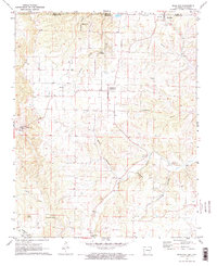 1972 Blue Eye1974 Print · USGSIn the early 1970s, the rural borderlands between Missouri and Arkansas centered on the shared community of Blue Eye. Researchers can trace decades of local history through sites like Cosmic Cavern, Oakgrove, and several family cemeteries including Boyd and Yocum.2 unique versions available
End of results
Showing maps 1-1 of 1
Top cities near Yocum
- Branson historical maps
- Berryville historical maps
- Hollister historical maps
- Green Forest historical maps
- Kimberling City historical maps
- Hough historical maps
See more
Frequently asked questions
- What are the different types of historical maps available for Yocum?
- What is the oldest map of Yocum?
- Where can I purchase historical maps of Yocum for my home or office?
- Where can I download high-res historical maps of Yocum?
- Are there historical topographic maps available for Yocum?
- Is there historical aerial imagery available for Yocum?
- Where are historical maps of Yocum sourced from?