1940s Maps of Nimmons, Arkansas
Explore 1 historic maps of Nimmons from the 1940s. These maps offer a rare glimpse into what life looked like during the 1940s — showing old roads, neighborhoods, homes, and landmarks that have changed or disappeared over time.
Whether you're researching your family's past, planning a metal detecting trip, or studying how Nimmons's landscape evolved across the 1940s, these high-resolution maps are a powerful tool for exploring the history of this region.
- Focus on a specific era: All maps on this page are from the 1940s, giving you a focused view of this time period.
- See what’s changed: Compare century-old streets, trails, and buildings to today's modern landscape using overlays and satellite layers.
- Research with precision: Use these maps for genealogy, historical research, land use analysis, or educational projects.
- View, download, or print: Maps are fully viewable online in high resolution, and can be downloaded or printed for your own records.
Start exploring Nimmons's history through authentic maps from the 1940s. This is your window into the past.
Nimmons, AR maps
(1)- 1940 Map of Piggott, 1945 Print
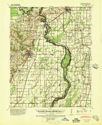 1940 Piggott1945 Print · USGSNortheast Arkansas and the Missouri Bootheel meet along the winding St Francis River in the decade before the post-war era. Genealogists and local historians can locate numerous rural landmarks including Gravel Hill Ch & Cem, Pine City, and the St Louis Southwestern RR line.
End of results
Showing maps 1-1 of 1
Top cities near Nimmons
- Kennett historical maps
- Piggott historical maps
- Steele historical maps
- Rector historical maps
- Campbell historical maps
- Senath historical maps
See more
Frequently asked questions
- What are the different types of historical maps available for Nimmons?
- What is the oldest map of Nimmons?
- Where can I purchase historical maps of Nimmons for my home or office?
- Where can I download high-res historical maps of Nimmons?
- Are there historical topographic maps available for Nimmons?
- Is there historical aerial imagery available for Nimmons?
- Where are historical maps of Nimmons sourced from?