1900s (20th Century) Maps of Sterling Springs, Arkansas
Explore 6 historic maps of Sterling Springs from the 1900s (20th Century). These maps offer a rare glimpse into what life looked like during the 1900s — showing old roads, neighborhoods, homes, and landmarks that have changed or disappeared over time.
Whether you're researching your family's past, planning a metal detecting trip, or studying how Sterling Springs's landscape evolved across the 1900s, these high-resolution maps are a powerful tool for exploring the history of this region.
- Focus on a specific era: All maps on this page are from the 1900s, giving you a focused view of this time period.
- See what’s changed: Compare century-old streets, trails, and buildings to today's modern landscape using overlays and satellite layers.
- Research with precision: Use these maps for genealogy, historical research, land use analysis, or educational projects.
- View, download, or print: Maps are fully viewable online in high resolution, and can be downloaded or printed for your own records.
Start exploring Sterling Springs's history through authentic maps from the 1900s. This is your window into the past.
Sterling Springs, AR maps
(6)- 1939 Map of Jonesboro, 1942 Print
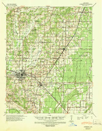 1939 Jonesboro1942 Print · USGSJonesboro and its surrounding farmstead communities are captured in the late thirties, when railroads and rural schools defined the region. Researchers can trace family sites like Higginsbottom Hope Sch or the remote Doss Flag Stop along the rail lines.
 - 1953 Map of Memphis, 1966 Print
 1953 Memphis1966 Print · USGSEastern Arkansas and the Memphis riverfront are shown here during the mid-century period of regional growth and river management. Local historians can trace the paths of the Chicago Rock Island & Pacific RR through Forrest City or locate river landmarks like President's Island.3 unique versions available
 - 1956 Map of Memphis
 1956 Memphis1956 Print · USGSThe Mississippi Delta and the bluffs of West Tennessee meet in the mid-fifties, showing a landscape defined by massive river systems and rail hubs. Researchers can trace the path of Crowleys Ridge or locate vanished river landings near Centennial Island and Island No 35.
 - 1958 Map of Jonesboro
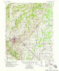 1958 Jonesboro1958 Print · USGSJonesboro and the surrounding Crowley's Ridge area are captured in the late fifties as the regional center expanded around Arkansas State College. Researchers can trace early rural life through an extensive network of landmarks like Indian Mounds, Nettleton, and the Philadelphia Ch & Cem.2 unique versions available
 - 1983 Map of Lorado, 1984 Print
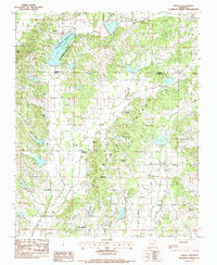 1983 Lorado1984 Print · USGSThe Greene and Craighead County borderlands are defined by the rising elevation of Crowleys Ridge in the late seventies. Family historians can trace local roots at Bethel Spring Cemetery and find old community hubs like Sterling Springs or Macedonia.
 - 1986 Map of Jonesboro
 1986 Jonesboro1986 Print · USGSNortheast Arkansas in the mid-eighties shows a landscape of intensive drainage and railroad junctions centered on the rise of Crowley's Ridge. Researchers can trace the rail corridors of the St Louis Southwestern Railway and explore the unique geography of Hatchie Coon Island and the Mississippi River floodplain.2 unique versions available
End of results
Showing maps 1-6 of 6
Top cities near Sterling Springs
- Jonesboro historical maps
- Paragould historical maps
- Walnut Ridge historical maps
- Bono historical maps
- Lake City historical maps
- Bay historical maps
See more
Frequently asked questions
- What are the different types of historical maps available for Sterling Springs?
- What is the oldest map of Sterling Springs?
- Where can I purchase historical maps of Sterling Springs for my home or office?
- Where can I download high-res historical maps of Sterling Springs?
- Are there historical topographic maps available for Sterling Springs?
- Is there historical aerial imagery available for Sterling Springs?
- Where are historical maps of Sterling Springs sourced from?