1930s Maps of Reed, Arkansas
Explore 2 historic maps of Reed from the 1930s. These maps offer a rare glimpse into what life looked like during the 1930s — showing old roads, neighborhoods, homes, and landmarks that have changed or disappeared over time.
Whether you're researching your family's past, planning a metal detecting trip, or studying how Reed's landscape evolved across the 1930s, these high-resolution maps are a powerful tool for exploring the history of this region.
- Focus on a specific era: All maps on this page are from the 1930s, giving you a focused view of this time period.
- See what’s changed: Compare century-old streets, trails, and buildings to today's modern landscape using overlays and satellite layers.
- Research with precision: Use these maps for genealogy, historical research, land use analysis, or educational projects.
- View, download, or print: Maps are fully viewable online in high resolution, and can be downloaded or printed for your own records.
Start exploring Reed's history through authentic maps from the 1930s. This is your window into the past.
Reed, AR maps
(2)- 1936 Map of McGehee, 1937 Print
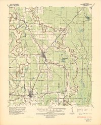 1936 McGehee1937 Print · USGSThe Arkansas Delta during the mid-thirties comes into focus through its dense network of bayous, rail junctions, and river towns. Genealogists and historians can trace the foundations of Mcgehee and Dermott, while locating rural landmarks like Loggy Bayou Church and the ancient INDIAN MOUNDS.
 - 1937 Map of McGehee, 1952 Print
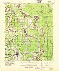 1937 McGehee1952 Print · USGSThe Arkansas Delta comes alive in the late 1930s as a complex network of bayous and rail lines. Genealogists and historians can trace the foundations of McGehee and Dermott, or locate rural landmarks like Providence Church and the Indian Mounds.
End of results
Showing maps 1-2 of 2
Top cities near Reed
- McGehee historical maps
- Dumas historical maps
- Dermott historical maps
- Mitchellville historical maps
- Watson historical maps
- Tillar historical maps
See more
Frequently asked questions
- What are the different types of historical maps available for Reed?
- What is the oldest map of Reed?
- Where can I purchase historical maps of Reed for my home or office?
- Where can I download high-res historical maps of Reed?
- Are there historical topographic maps available for Reed?
- Is there historical aerial imagery available for Reed?
- Where are historical maps of Reed sourced from?