1960s Maps of Killin, Monticello
Explore 2 historic maps of Killin from the 1960s. These maps offer a rare glimpse into what life looked like during the 1960s — showing old roads, neighborhoods, homes, and landmarks that have changed or disappeared over time.
Whether you're researching your family's past, planning a metal detecting trip, or studying how Killin's landscape evolved across the 1960s, these high-resolution maps are a powerful tool for exploring the history of this region.
- Focus on a specific era: All maps on this page are from the 1960s, giving you a focused view of this time period.
- See what’s changed: Compare century-old streets, trails, and buildings to today's modern landscape using overlays and satellite layers.
- Research with precision: Use these maps for genealogy, historical research, land use analysis, or educational projects.
- View, download, or print: Maps are fully viewable online in high resolution, and can be downloaded or printed for your own records.
Start exploring Killin's history through authentic maps from the 1960s. This is your window into the past.
Killin, Monticello maps
(2)- 1960 Map of Collins, 1961 Print
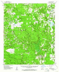 1960 Collins1961 Print · USGSIn the early sixties, the Drew County landscape was a tapestry of rail-side settlements and brake-water bayous. Researchers can trace family history through sites like Selma, the Missouri Pacific line, and cemeteries such as Dabney Cem or Mt Olive Cem.
 - 1960 Map of Cominto, 1961 Print
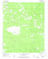 1960 Cominto1961 Print · USGSIn the early sixties, this portion of Drew County remained a landscape of scattered rural settlements and logging-era rail lines. Researchers can trace family history at Rash Cem and Moore Cem or locate the old Enon School along the Missouri Pacific tracks.2 unique versions available
End of results
Showing maps 1-2 of 2
Top cities near Killin
Frequently asked questions
- What are the different types of historical maps available for Killin?
- What is the oldest map of Killin?
- Where can I purchase historical maps of Killin for my home or office?
- Where can I download high-res historical maps of Killin?
- Are there historical topographic maps available for Killin?
- Is there historical aerial imagery available for Killin?
- Where are historical maps of Killin sourced from?