1980s Maps of Batesville, Arkansas
Explore 3 historic maps of Batesville from the 1980s. These maps offer a rare glimpse into what life looked like during the 1980s — showing old roads, neighborhoods, homes, and landmarks that have changed or disappeared over time.
Whether you're researching your family's past, planning a metal detecting trip, or studying how Batesville's landscape evolved across the 1980s, these high-resolution maps are a powerful tool for exploring the history of this region.
- Focus on a specific era: All maps on this page are from the 1980s, giving you a focused view of this time period.
- See what’s changed: Compare century-old streets, trails, and buildings to today's modern landscape using overlays and satellite layers.
- Research with precision: Use these maps for genealogy, historical research, land use analysis, or educational projects.
- View, download, or print: Maps are fully viewable online in high resolution, and can be downloaded or printed for your own records.
Start exploring Batesville's history through authentic maps from the 1980s. This is your window into the past.
Batesville, AR maps
(3)- 1986 Map of Batesville
 1986 Batesville1986 Print · USGSNorth-central Arkansas in the mid-eighties shows a landscape of river-bend towns and Ozark foothills during a period of steady growth. You can trace family roots through numerous upland sites like Hickory Valley School, Sandtown Hill Cem, and the riverfront at Oil Trough.2 unique versions available
 - 1989 Map of Batesville
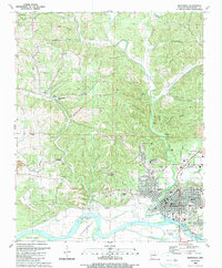 1989 Batesville1989 Print · USGSBatesville and its rugged river valley surroundings are captured in the late eighties as a bustling center of education and industry. Researchers can find numerous family cemeteries like Greenfield Cem, local landmarks like Big Spring Mill, and the riverside campus of Arkansas College.
 - 1989 Map of Sulphur Rock, 1990 Print
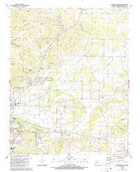 1989 Sulphur Rock1990 Print · USGSIndependence County's landscape east of Batesville shows a unique mix of mid-century infrastructure and pioneer-era roots in the late 1980s. Genealogists and historians can trace numerous family cemeteries like Harvison Cem and landmarks such as the Old RR Gr or Arkansas College.
End of results
Showing maps 1-3 of 3
Top cities near Batesville
- Southside historical maps
- Cave City historical maps
- Newark historical maps
- Cushman historical maps
- Sulphur Rock historical maps
- Mount Pleasant historical maps
See more
Top neighborhoods of Batesville
- Eastwood Addition historical maps
- Meadow Heights historical maps
- Sun Valley Addition historical maps
- Wolford Addition historical maps
- Pegg Addition historical maps
- Rogers Addition historical maps
See more
Frequently asked questions
- What are the different types of historical maps available for Batesville?
- What is the oldest map of Batesville?
- Where can I purchase historical maps of Batesville for my home or office?
- Where can I download high-res historical maps of Batesville?
- Are there historical topographic maps available for Batesville?
- Is there historical aerial imagery available for Batesville?
- Where are historical maps of Batesville sourced from?