1940s Maps of Limedale, Arkansas
Explore 2 historic maps of Limedale from the 1940s. These maps offer a rare glimpse into what life looked like during the 1940s — showing old roads, neighborhoods, homes, and landmarks that have changed or disappeared over time.
Whether you're researching your family's past, planning a metal detecting trip, or studying how Limedale's landscape evolved across the 1940s, these high-resolution maps are a powerful tool for exploring the history of this region.
- Focus on a specific era: All maps on this page are from the 1940s, giving you a focused view of this time period.
- See what’s changed: Compare century-old streets, trails, and buildings to today's modern landscape using overlays and satellite layers.
- Research with precision: Use these maps for genealogy, historical research, land use analysis, or educational projects.
- View, download, or print: Maps are fully viewable online in high resolution, and can be downloaded or printed for your own records.
Start exploring Limedale's history through authentic maps from the 1940s. This is your window into the past.
Limedale, AR maps
(2)- 1942 Map of Batesville, 1945 Print
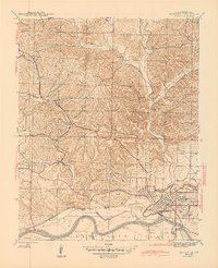 1942 Batesville1945 Print · USGSBatesville and its riverfront industry are captured here during the 1940s as a vital hub for rail and river transport. Genealogists and historians can trace the foundations of Independence County through local landmarks like the Aydelotte Mine, Big Spring Mill, and Pleasant Valley Cemeteries.2 unique versions available
 - 1943 Map of Batesville, 1956 Print
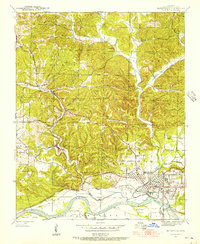 1943 Batesville1956 Print · USGSBatesville and the White River valley were bustling hubs of rail and river commerce during the early 1940s. Genealogists and historians can trace old landmarks like the Masonic Home, family burial sites at Pleasant Valley Cemeteries, and industrial works like the Gibson Mine.4 unique versions available
End of results
Showing maps 1-2 of 2
Top cities near Limedale
- Batesville historical maps
- Southside historical maps
- Cave City historical maps
- Cushman historical maps
- Sulphur Rock historical maps
- Mount Pleasant historical maps
See more
Frequently asked questions
- What are the different types of historical maps available for Limedale?
- What is the oldest map of Limedale?
- Where can I purchase historical maps of Limedale for my home or office?
- Where can I download high-res historical maps of Limedale?
- Are there historical topographic maps available for Limedale?
- Is there historical aerial imagery available for Limedale?
- Where are historical maps of Limedale sourced from?